 Warner Robins
Wantagh
Bethel
Misty Hill Farm
United States
Wakonda Beach (R33) Airport
Wilmington
Poland
Miami International Airport
Warner Robins
Wantagh
Bethel
Misty Hill Farm
United States
Wakonda Beach (R33) Airport
Wilmington
Poland
Miami International Airport
Wapato Park on the map, Tacoma, United States
Photo
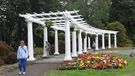
Where is located Wapato Park
Wapato Park — local attraction, which is located at 6500 S Sheridan Ave, Tacoma, WA 98408, United States and belongs to the category — park. Average visitor rating for this place — 4.5 (according to 3081 rating, information from open sources and relevant for 2022).
Exact location — Wapato Park, marked on the map with a red marker.
You can get directions to Wapato Park on the map from your location.
What else is interesting in Tacoma? You can see all the sights if you go to the city page.
Coordinates
Wapato Park, United States coordinates in decimal format: latitude — 47.197349047103295, longitude — -122.46052122125107. When converted to degrees, minutes, seconds Wapato Park has the following coordinates: 47°11′50.46 north latitude and -122°27′37.88 east longitude.
Nearby cities
The largest cities that are located nearby:
- Seattle — 40 km
- Bellevue — 43 km
- Victoria
 (Canada) — 147 km
 - Vancouver — 179 km
- Portland — 192 km
- Abbotsford (Canada) — 199 km
- Delta (Canada) — 208 km
- Surrey (Canada) — 215 km
- Richmond (Canada) — 217 km
- Burnaby (Canada) — 226 km
- Coquitlam (Canada) — 226 km
- Anmore (Canada) — 230 km
- Salem — 260 km
- Eugene — 358 km
- Kelowna (Canada) — 359 km
- Spokane — 376 km
- Boise — 640 km
- Calgary (Canada) — 718 km
- Reno — 883 km
Distance to the capital
Distance to the capital (Washington) is about — 3749 km.