 Warner Robins
Wantagh
Bethel
Misty Hill Farm
United States
Wakonda Beach (R33) Airport
Wilmington
Poland
Miami International Airport
Warner Robins
Wantagh
Bethel
Misty Hill Farm
United States
Wakonda Beach (R33) Airport
Wilmington
Poland
Miami International Airport
Norfolk Historical Society on the map, Norfolk, United States
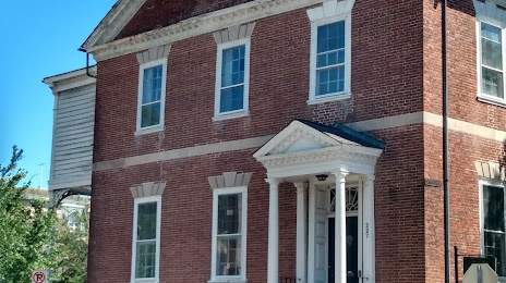
Photo
Where is located Norfolk Historical Society
Norfolk Historical Society — local attraction, which is located at 227 W Freemason St, Norfolk, VA 23510, United States and belongs to the category — museum. Average visitor rating for this place — 4.3 (according to 4 ratings, information from open sources and relevant for 2022).
Exact location — Norfolk Historical Society, marked on the map with a red marker.
You can get directions to Norfolk Historical Society on the map from your location.
What else is interesting in Norfolk? You can see all the sights if you go to the city page.
Coordinates
Norfolk Historical Society, United States coordinates in decimal format: latitude — 36.85411915201385, longitude — -76.299507226464. When converted to degrees, minutes, seconds Norfolk Historical Society has the following coordinates: 36°51′14.83 north latitude and -76°17′58.23 east longitude.
Nearby cities
The largest cities that are located nearby:
- Chesapeake — 9 km
- Hampton — 20 km
- Virginia Beach — 27 km
- Richmond — 126 km
- Alexandria — 226 km
- Raleigh — 242 km
- Durham — 252 km
- Cary — 253 km
- Baltimore — 271 km
- Fayetteville — 308 km
- Greensboro — 325 km
- Philadelphia — 356 km
- Winston-Salem — 363 km
- Toms River — 386 km
- Allentown — 421 km
- Edison — 435 km
- Charlotte — 449 km
- Elizabeth — 456 km
- Newark — 465 km
Distance to the capital
Distance to the capital (Washington) is about — 237 km.