 Warner Robins
Wantagh
Bethel
Misty Hill Farm
United States
Wakonda Beach (R33) Airport
Wilmington
Poland
Miami International Airport
Warner Robins
Wantagh
Bethel
Misty Hill Farm
United States
Wakonda Beach (R33) Airport
Wilmington
Poland
Miami International Airport
Sanguinetti Memorial Park on the map, Yuma, United States
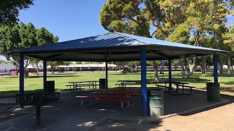
Photo
Where is located Sanguinetti Memorial Park
Sanguinetti Memorial Park — local attraction, which is located at S 8th Ave & 23rd Street, 2011 S 6th Ave, Yuma, AZ 85364, United States and belongs to the category — park. Average visitor rating for this place — 4.2 (according to 279 ratings, information from open sources and relevant for 2022).
Exact location — Sanguinetti Memorial Park, marked on the map with a red marker.
You can get directions to Sanguinetti Memorial Park on the map from your location.
What else is interesting in Yuma? You can see all the sights if you go to the city page.
Coordinates
Sanguinetti Memorial Park, United States coordinates in decimal format: latitude — 32.68668314700775, longitude — -114.62784397527088. When converted to degrees, minutes, seconds Sanguinetti Memorial Park has the following coordinates: 32°41′12.06 north latitude and -114°37′40.24 east longitude.
Nearby cities
The largest cities that are located nearby:
- San Luis Río Colorado
 (Mexico) — 30 km
 - Mexicali (Mexico) — 77 km
- Ensenada (Mexico) — 207 km
- Tijuana (Mexico) — 226 km
- Chula Vista — 229 km
- Escondido — 232 km
- San Diego — 236 km
- Peoria — 241 km
- Glendale — 244 km
- Phoenix — 250 km
- Oceanside — 261 km
- Tempe — 261 km
- Scottsdale — 264 km
- Chandler — 266 km
- Mesa — 270 km
- Gilbert — 272 km
- Moreno Valley — 276 km
- San Bernardino — 290 km
- Riverside — 290 km
Distance to the capital
Distance to the capital (Washington) is about — 3436 km.