 Warner Robins
Wantagh
Bethel
Misty Hill Farm
United States
Wakonda Beach (R33) Airport
Wilmington
Poland
Miami International Airport
Warner Robins
Wantagh
Bethel
Misty Hill Farm
United States
Wakonda Beach (R33) Airport
Wilmington
Poland
Miami International Airport
The Logan Mansion on the map, Shreveport, United States
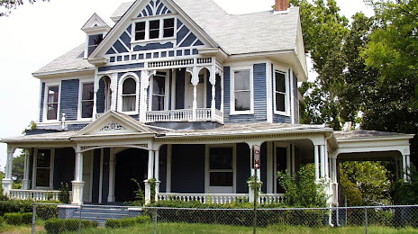
Photo
Where is located The Logan Mansion
The Logan Mansion — local attraction, which is located at 725 Austen Pl, Shreveport, LA 71101, United States and belongs to the category — historical place. Average visitor rating for this place — 4.6 (according to 75 ratings, information from open sources and relevant for 2022).
Exact location — The Logan Mansion, marked on the map with a red marker.
You can get directions to The Logan Mansion on the map from your location.
What else is interesting in Shreveport? You can see all the sights if you go to the city page.
Coordinates
The Logan Mansion, United States coordinates in decimal format: latitude — 32.506625965326236, longitude — -93.75395327527539. When converted to degrees, minutes, seconds The Logan Mansion has the following coordinates: 32°30′23.85 north latitude and -93°45′14.23 east longitude.
Nearby cities
The largest cities that are located nearby:
- Mesquite — 266 km
- Garland — 272 km
- Beaumont — 273 km
- Plano — 279 km
- Little Rock — 279 km
- Richardson — 280 km
- Dallas — 285 km
- Frisco — 293 km
- Carrollton — 295 km
- Irving — 299 km
- Grand Prairie — 303 km
- Lafayette — 303 km
- Arlington — 313 km
- Denton — 322 km
- Fort Worth — 334 km
- Jackson — 334 km
- Waco — 338 km
- Baton Rouge — 338 km
- Houston — 343 km
Distance to the capital
Distance to the capital (Washington) is about — 1666 km.