 Warner Robins
Wantagh
Bethel
Misty Hill Farm
United States
Wakonda Beach (R33) Airport
Wilmington
Poland
Miami International Airport
Warner Robins
Wantagh
Bethel
Misty Hill Farm
United States
Wakonda Beach (R33) Airport
Wilmington
Poland
Miami International Airport
Pine Bluff Regional Park on the map, Pine Bluff, United States
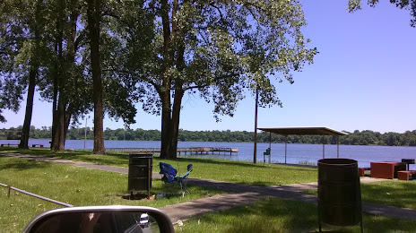
Photo
Where is located Pine Bluff Regional Park
Pine Bluff Regional Park — local attraction, which is located at 6300 W 4th Ave, Pine Bluff, AR 71602, United States and belongs to the category — park. Average visitor rating for this place — 4.2 (according to 323 ratings, information from open sources and relevant for 2022).
Exact location — Pine Bluff Regional Park, marked on the map with a red marker.
You can get directions to Pine Bluff Regional Park on the map from your location.
What else is interesting in Pine Bluff? You can see all the sights if you go to the city page.
Coordinates
Pine Bluff Regional Park, United States coordinates in decimal format: latitude — 34.24547847086315, longitude — -91.99066397523043. When converted to degrees, minutes, seconds Pine Bluff Regional Park has the following coordinates: 34°14′43.72 north latitude and -91°59′26.39 east longitude.
Nearby cities
The largest cities that are located nearby:
- Little Rock — 63 km
- Memphis — 204 km
- Shreveport — 249 km
- Jackson — 273 km
- Springfield — 349 km
- Tulsa — 415 km
- Baton Rouge — 425 km
- Lafayette — 443 km
- Garland — 454 km
- Plano — 455 km
- Mesquite — 457 km
- Richardson — 461 km
- Frisco — 462 km
- Dallas — 474 km
- Carrollton — 474 km
- Clarksville — 485 km
- Irving — 485 km
- Birmingham — 486 km
- Denton — 488 km
Distance to the capital
Distance to the capital (Washington) is about — 1431 km.