 Warner Robins
Wantagh
Bethel
Misty Hill Farm
United States
Wakonda Beach (R33) Airport
Wilmington
Poland
Miami International Airport
Warner Robins
Wantagh
Bethel
Misty Hill Farm
United States
Wakonda Beach (R33) Airport
Wilmington
Poland
Miami International Airport
Camelot Park on the map, Bakersfield, United States
Photo
Where is located Camelot Park
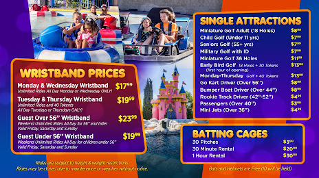
Camelot Park — local attraction, which is located at 1251 Oak St, Bakersfield, CA 93304, United States and belongs to the category — amusement center. Average visitor rating for this place — 4.0 (according to 1156 ratings, information from open sources and relevant for 2022).
Exact location — Camelot Park, marked on the map with a red marker.
You can get directions to Camelot Park on the map from your location.
What else is interesting in Bakersfield? You can see all the sights if you go to the city page.
Coordinates
Camelot Park, United States coordinates in decimal format: latitude — 35.369943611436284, longitude — -119.03990337520032. When converted to degrees, minutes, seconds Camelot Park has the following coordinates: 35°22′11.8 north latitude and -119°2′23.65 east longitude.
Nearby cities
The largest cities that are located nearby:
- Visalia — 109 km
- Lancaster — 109 km
- Santa Clarita — 112 km
- Santa Clarita — 117 km
- Palmdale — 120 km
- Simi Valley — 124 km
- Oxnard — 131 km
- Thousand Oaks — 134 km
- Burbank — 147 km
- Universal City — 149 km
- Glendale — 153 km
- Pasadena — 157 km
- Los Angeles — 162 km
- Fresno — 166 km
- Inglewood — 168 km
- East Los Angeles — 169 km
- El Monte — 170 km
- West Covina — 175 km
- Downey — 178 km
Distance to the capital
Distance to the capital (Washington) is about — 3712 km.