 Warner Robins
Wantagh
Bethel
Misty Hill Farm
United States
Wakonda Beach (R33) Airport
Wilmington
Poland
Miami International Airport
Warner Robins
Wantagh
Bethel
Misty Hill Farm
United States
Wakonda Beach (R33) Airport
Wilmington
Poland
Miami International Airport
Sioux City Art Center on the map, Sioux City, United States
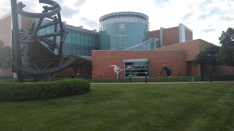
Photo
Where is located Sioux City Art Center
Sioux City Art Center — local attraction, which is located at 225 Nebraska St, Sioux City, IA 51101, United States and belongs to the category — art museum. Average visitor rating for this place — 4.7 (according to 195 ratings, information from open sources and relevant for 2022).
Exact location — Sioux City Art Center, marked on the map with a red marker.
You can get directions to Sioux City Art Center on the map from your location.
What else is interesting in Sioux City? You can see all the sights if you go to the city page.
Coordinates
Sioux City Art Center, United States coordinates in decimal format: latitude — 42.492744779484475, longitude — -96.40404957499005. When converted to degrees, minutes, seconds Sioux City Art Center has the following coordinates: 42°29′33.88 north latitude and -96°24′14.58 east longitude.
Nearby cities
The largest cities that are located nearby:
- Sioux Falls — 118 km
- Omaha — 142 km
- Lincoln — 187 km
- Des Moines — 251 km
- Minneapolis — 368 km
- Saint Paul — 375 km
- Topeka — 386 km
- North Kansas City — 403 km
- Kansas City — 407 km
- Independence — 414 km
- Overland Park — 416 km
- Olathe — 423 km
- Wichita — 538 km
- Madison — 569 km
- Rockford — 598 km
- Peoria — 605 km
- Springfield — 646 km
- Aurora — 671 km
- Naperville — 685 km
Distance to the capital
Distance to the capital (Washington) is about — 1677 km.