 Warner Robins
Wantagh
Bethel
Misty Hill Farm
United States
Wakonda Beach (R33) Airport
Wilmington
Poland
Miami International Airport
Warner Robins
Wantagh
Bethel
Misty Hill Farm
United States
Wakonda Beach (R33) Airport
Wilmington
Poland
Miami International Airport
Scott Springs Park on the map, Ocala, United States
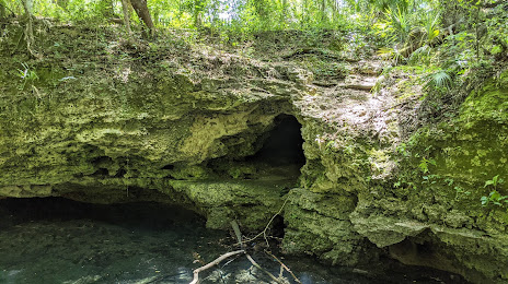
Photo
Where is located Scott Springs Park
Scott Springs Park — local attraction, which is located at 2825 SW 24th Ave, Ocala, FL 34471, United States and belongs to the category — park. Average visitor rating for this place — 4.6 (according to 450 ratings, information from open sources and relevant for 2022).
Exact location — Scott Springs Park, marked on the map with a red marker.
You can get directions to Scott Springs Park on the map from your location.
What else is interesting in Ocala? You can see all the sights if you go to the city page.
Coordinates
Scott Springs Park, United States coordinates in decimal format: latitude — 29.161249021830763, longitude — -82.16380797535598. When converted to degrees, minutes, seconds Scott Springs Park has the following coordinates: 29°9′40.5 north latitude and -82°9′49.71 east longitude.
Nearby cities
The largest cities that are located nearby:
- Gainesville — 54 km
- Orlando — 103 km
- Jacksonville — 135 km
- Brandon — 139 km
- Tampa — 140 km
- Clearwater — 150 km
- Saint Petersburg — 164 km
- Tallahassee — 247 km
- Port Saint Lucie — 275 km
- Cape Coral — 291 km
- Savannah — 335 km
- Coral Springs — 372 km
- Fort Lauderdale — 393 km
- Pembroke Pines — 396 km
- Miramar — 398 km
- Hollywood — 403 km
- Hialeah — 412 km
- Miami — 426 km
- Charleston — 447 km
Distance to the capital
Distance to the capital (Washington) is about — 1182 km.