 Warner Robins
Wantagh
Bethel
Misty Hill Farm
United States
Wakonda Beach (R33) Airport
Wilmington
Poland
Miami International Airport
Warner Robins
Wantagh
Bethel
Misty Hill Farm
United States
Wakonda Beach (R33) Airport
Wilmington
Poland
Miami International Airport
The Naples Preserve on the map, Naples, United States
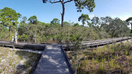
Photo
Where is located The Naples Preserve
The Naples Preserve — local attraction, which is located at 1690 Tamiami Trail N, Naples, FL 34102, United States and belongs to the category — nature preserve. Average visitor rating for this place — 4.5 (according to 170 ratings, information from open sources and relevant for 2022).
Exact location — The Naples Preserve, marked on the map with a red marker.
You can get directions to The Naples Preserve on the map from your location.
What else is interesting in Naples? You can see all the sights if you go to the city page.
Coordinates
The Naples Preserve, United States coordinates in decimal format: latitude — 26.167181651840178, longitude — -81.79874767542124. When converted to degrees, minutes, seconds The Naples Preserve has the following coordinates: 26°10′1.85 north latitude and -81°47′55.49 east longitude.
Nearby cities
The largest cities that are located nearby:
- Cape Coral — 49 km
- Miramar — 149 km
- Pembroke Pines — 150 km
- Coral Springs — 152 km
- Hialeah — 154 km
- Hollywood — 164 km
- Fort Lauderdale — 165 km
- Miami — 165 km
- Port Saint Lucie — 189 km
- Saint Petersburg — 198 km
- Brandon — 204 km
- Tampa — 210 km
- Clearwater — 224 km
- Orlando — 268 km
- Havana
 (Cuba) — 333 km
 - Matanzas (Cuba) — 345 km
- Gainesville — 391 km
- Santa Clara (Cuba) — 453 km
- Pinar del Río (Cuba) — 455 km
Distance to the capital
Distance to the capital (Washington) is about — 1485 km.