 Warner Robins
Wantagh
Bethel
Misty Hill Farm
United States
Wakonda Beach (R33) Airport
Wilmington
Poland
Miami International Airport
Warner Robins
Wantagh
Bethel
Misty Hill Farm
United States
Wakonda Beach (R33) Airport
Wilmington
Poland
Miami International Airport
Turkey Creek Nature Trail on the map, Niceville, United States
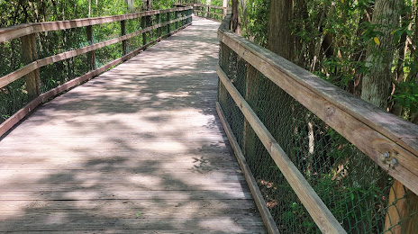
Photo
Where is located Turkey Creek Nature Trail
Turkey Creek Nature Trail — local attraction, which is located at 340 E John Sims Pkwy, Choctaw Beach, FL 32578, United States and belongs to the category — park. Average visitor rating for this place — 4.8 (according to 45 ratings, information from open sources and relevant for 2022).
Exact location — Turkey Creek Nature Trail, marked on the map with a red marker.
You can get directions to Turkey Creek Nature Trail on the map from your location.
What else is interesting in Niceville? You can see all the sights if you go to the city page.
Coordinates
Turkey Creek Nature Trail, United States coordinates in decimal format: latitude — 30.523768892638063, longitude — -86.4984807753241. When converted to degrees, minutes, seconds Turkey Creek Nature Trail has the following coordinates: 30°31′25.57 north latitude and -86°29′54.53 east longitude.
Nearby cities
The largest cities that are located nearby:
- Mobile — 149 km
- Montgomery — 205 km
- Tallahassee — 210 km
- Birmingham — 333 km
- New Orleans — 349 km
- Metairie — 356 km
- Jackson — 398 km
- Atlanta — 406 km
- Gainesville — 411 km
- Baton Rouge — 444 km
- Clearwater — 457 km
- Jacksonville — 461 km
- Huntsville — 466 km
- Saint Petersburg — 483 km
- Tampa — 485 km
- Brandon — 499 km
- Chattanooga — 512 km
- Lafayette — 530 km
- Savannah — 533 km
Distance to the capital
Distance to the capital (Washington) is about — 1270 km.