 Warner Robins
Wantagh
Bethel
Misty Hill Farm
United States
Wakonda Beach (R33) Airport
Wilmington
Poland
Miami International Airport
Warner Robins
Wantagh
Bethel
Misty Hill Farm
United States
Wakonda Beach (R33) Airport
Wilmington
Poland
Miami International Airport
Shale Hollow Park on the map, Lewis Center, United States
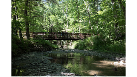
Photo
Where is located Shale Hollow Park
Shale Hollow Park — local attraction, which is located at 6320 Artesian Run, Delaware, OH 43015, United States and belongs to the category — park. Average visitor rating for this place — 4.8 (according to 323 ratings, information from open sources and relevant for 2022).
Exact location — Shale Hollow Park, marked on the map with a red marker.
You can get directions to Shale Hollow Park on the map from your location.
What else is interesting in Lewis Center? You can see all the sights if you go to the city page.
Coordinates
Shale Hollow Park, United States coordinates in decimal format: latitude — 40.20533780641374, longitude — -83.03452767506106. When converted to degrees, minutes, seconds Shale Hollow Park has the following coordinates: 40°12′19.22 north latitude and -83°2′4.3 east longitude.
Nearby cities
The largest cities that are located nearby:
- Columbus — 26 km
- Springfield — 74 km
- Akron — 158 km
- Toledo — 168 km
- Cincinnati — 177 km
- Cleveland — 180 km
- Aurora — 186 km
- Fort Wayne — 202 km
- Windsor
 (Canada) — 234 km
 - Detroit — 236 km
- Ann Arbor — 238 km
- Pittsburgh — 255 km
- Warren — 256 km
- Sterling Heights — 263 km
- Indianapolis — 272 km
- Lansing — 307 km
- South Bend — 314 km
- Flint — 316 km
- Louisville — 321 km
Distance to the capital
Distance to the capital (Washington) is about — 534 km.