 Warner Robins
Wantagh
Bethel
Misty Hill Farm
United States
Wakonda Beach (R33) Airport
Wilmington
Poland
Miami International Airport
Warner Robins
Wantagh
Bethel
Misty Hill Farm
United States
Wakonda Beach (R33) Airport
Wilmington
Poland
Miami International Airport
Historic New Bridge Landing on the map, Paramus, United States
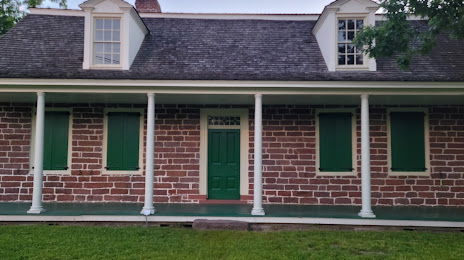
Photo
Where is located Historic New Bridge Landing
Historic New Bridge Landing — local attraction, which is located at 1205 Main St, River Edge, NJ 07661, United States and belongs to the category — historical landmark. Average visitor rating for this place — 4.6 (according to 111 ratings, information from open sources and relevant for 2022).
Exact location — Historic New Bridge Landing, marked on the map with a red marker.
You can get directions to Historic New Bridge Landing on the map from your location.
What else is interesting in Paramus? You can see all the sights if you go to the city page.
Coordinates
Historic New Bridge Landing, United States coordinates in decimal format: latitude — 40.913080594113104, longitude — -74.03124707503947. When converted to degrees, minutes, seconds Historic New Bridge Landing has the following coordinates: 40°54′47.09 north latitude and -74°1′52.49 east longitude.
Nearby cities
The largest cities that are located nearby:
- Paterson — 9 km
- Yonkers — 15 km
- Newark — 24 km
- New York — 26 km
- Brooklyn — 28 km
- Elizabeth — 33 km
- Stamford — 46 km
- Edison — 55 km
- Bridgeport — 78 km
- New Haven — 103 km
- Waterbury — 109 km
- Toms River — 110 km
- Allentown — 124 km
- Philadelphia — 143 km
- Hartford — 146 km
- Springfield — 177 km
- Amherst — 201 km
- Worcester — 236 km
- Providence — 240 km
Distance to the capital
Distance to the capital (Washington) is about — 340 km.