 Warner Robins
Wantagh
Bethel
Misty Hill Farm
United States
Wakonda Beach (R33) Airport
Wilmington
Poland
Miami International Airport
Warner Robins
Wantagh
Bethel
Misty Hill Farm
United States
Wakonda Beach (R33) Airport
Wilmington
Poland
Miami International Airport
Indian Canyon Mystic Falls on the map, Spokane, United States
Photo
Where is located Indian Canyon Mystic Falls
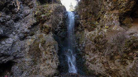
Indian Canyon Mystic Falls — local attraction, which is located at 4812 W Canyon Dr, Spokane, WA 99224, United States and belongs to the category — park. Average visitor rating for this place — 4.6 (according to 384 ratings, information from open sources and relevant for 2022).
Exact location — Indian Canyon Mystic Falls, marked on the map with a red marker.
You can get directions to Indian Canyon Mystic Falls on the map from your location.
What else is interesting in Spokane? You can see all the sights if you go to the city page.
Coordinates
Indian Canyon Mystic Falls, United States coordinates in decimal format: latitude — 47.648957754515216, longitude — -117.48228907481857. When converted to degrees, minutes, seconds Indian Canyon Mystic Falls has the following coordinates: 47°38′56.25 north latitude and -117°28′56.24 east longitude.
Nearby cities
The largest cities that are located nearby:
- Kelowna
 (Canada) — 287 km
 - Bellevue — 356 km
- Seattle — 366 km
- Tacoma — 379 km
- Abbotsford (Canada) — 387 km
- Surrey (Canada) — 427 km
- Coquitlam (Canada) — 427 km
- Anmore (Canada) — 432 km
- Delta (Canada) — 435 km
- Burnaby (Canada) — 438 km
- Calgary (Canada) — 441 km
- Victoria (Canada) — 444 km
- Richmond (Canada) — 445 km
- Vancouver (Canada) — 448 km
- Boise — 457 km
- Portland — 470 km
- Salem — 532 km
- Eugene — 601 km
- Edmonton (Canada) — 700 km
Distance to the capital
Distance to the capital (Washington) is about — 3374 km.