 Warner Robins
Wantagh
Bethel
Misty Hill Farm
United States
Wakonda Beach (R33) Airport
Wilmington
Poland
Miami International Airport
Warner Robins
Wantagh
Bethel
Misty Hill Farm
United States
Wakonda Beach (R33) Airport
Wilmington
Poland
Miami International Airport
Shadow Creek Ranch Nature Trail on the map, Pearland, United States
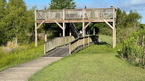
Photo
Where is located Shadow Creek Ranch Nature Trail
Shadow Creek Ranch Nature Trail — local attraction, which is located at 1801 Kingsley Dr, Pearland, TX 77584, United States and belongs to the category — city park. Average visitor rating for this place — 4.5 (according to 166 ratings, information from open sources and relevant for 2022).
Exact location — Shadow Creek Ranch Nature Trail, marked on the map with a red marker.
You can get directions to Shadow Creek Ranch Nature Trail on the map from your location.
What else is interesting in Pearland? You can see all the sights if you go to the city page.
Coordinates
Shadow Creek Ranch Nature Trail, United States coordinates in decimal format: latitude — 29.580729895036228, longitude — -95.4165799753463. When converted to degrees, minutes, seconds Shadow Creek Ranch Nature Trail has the following coordinates: 29°34′50.63 north latitude and -95°24′59.69 east longitude.
Nearby cities
The largest cities that are located nearby:
- Houston — 23 km
- Beaumont — 125 km
- Austin — 247 km
- Waco — 281 km
- Corpus Christi — 284 km
- Killeen — 288 km
- San Antonio — 309 km
- Lafayette — 320 km
- Shreveport — 357 km
- Mesquite — 375 km
- Dallas — 382 km
- Grand Prairie — 386 km
- Arlington — 390 km
- Garland — 391 km
- Irving — 391 km
- Richardson — 397 km
- Fort Worth — 401 km
- Plano — 404 km
- Carrollton — 406 km
Distance to the capital
Distance to the capital (Washington) is about — 1977 km.