 Warner Robins
Wantagh
Bethel
Misty Hill Farm
United States
Wakonda Beach (R33) Airport
Wilmington
Poland
Miami International Airport
Warner Robins
Wantagh
Bethel
Misty Hill Farm
United States
Wakonda Beach (R33) Airport
Wilmington
Poland
Miami International Airport
Kelly Park - Rock Springs on the map, Apopka, United States
Photo
Where is located Kelly Park - Rock Springs
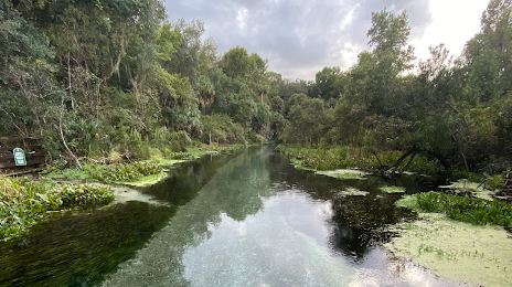
Kelly Park - Rock Springs — local attraction, which is located at 400 E Kelly Park Rd, Apopka, FL 32712, United States and belongs to the category — hiking area. Average visitor rating for this place — 4.8 (according to 44 ratings, information from open sources and relevant for 2022).
Exact location — Kelly Park - Rock Springs, marked on the map with a red marker.
You can get directions to Kelly Park - Rock Springs on the map from your location.
What else is interesting in Apopka? You can see all the sights if you go to the city page.
Coordinates
Kelly Park - Rock Springs, United States coordinates in decimal format: latitude — 28.756950607036334, longitude — -81.50104517536515. When converted to degrees, minutes, seconds Kelly Park - Rock Springs has the following coordinates: 28°45′25.02 north latitude and -81°30′3.76 east longitude.
Nearby cities
The largest cities that are located nearby:
- Orlando — 23 km
- Brandon — 111 km
- Tampa — 122 km
- Gainesville — 130 km
- Clearwater — 148 km
- Saint Petersburg — 149 km
- Jacksonville — 182 km
- Port Saint Lucie — 195 km
- Cape Coral — 239 km
- Coral Springs — 296 km
- Fort Lauderdale — 316 km
- Pembroke Pines — 321 km
- Miramar — 323 km
- Tallahassee — 325 km
- Hollywood — 327 km
- Hialeah — 337 km
- Miami — 351 km
- Savannah — 377 km
- Charleston — 475 km
Distance to the capital
Distance to the capital (Washington) is about — 1202 km.