 Warner Robins
Wantagh
Bethel
Misty Hill Farm
United States
Wakonda Beach (R33) Airport
Wilmington
Poland
Miami International Airport
Warner Robins
Wantagh
Bethel
Misty Hill Farm
United States
Wakonda Beach (R33) Airport
Wilmington
Poland
Miami International Airport
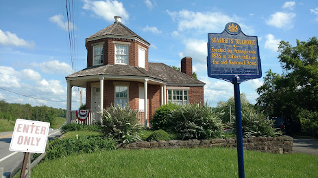
Searights Tollhouse, National Road on the map, Uniontown, United States
Photo
Where is located Searights Tollhouse, National Road
Searights Tollhouse, National Road — local attraction, which is located at 7328 National Pike E, Uniontown, PA 15401, United States and belongs to the category — toll house. Average visitor rating for this place — 4.8 (according to 15 ratings, information from open sources and relevant for 2022).
Exact location — Searights Tollhouse, National Road, marked on the map with a red marker.
You can get directions to Searights Tollhouse, National Road on the map from your location.
What else is interesting in Uniontown? You can see all the sights if you go to the city page.
Coordinates
Searights Tollhouse, National Road, United States coordinates in decimal format: latitude — 39.947252966435364, longitude — -79.79416147506889. When converted to degrees, minutes, seconds Searights Tollhouse, National Road has the following coordinates: 39°56′50.11 north latitude and -79°47′38.98 east longitude.
Nearby cities
The largest cities that are located nearby:
- Pittsburgh — 64 km
- Akron — 199 km
- Aurora — 207 km
- Cleveland — 241 km
- Alexandria — 260 km
- Baltimore — 274 km
- Columbus — 278 km
- Boston — 312 km
- Richmond — 329 km
- Buffalo — 337 km
- Springfield — 347 km
- Amherst — 348 km
- Saint Catharines
 (Canada) — 362 km
 - London (Canada) — 363 km
- Allentown — 363 km
- Hamilton (Canada) — 371 km
- Toledo — 372 km
- Burlington (Canada) — 379 km
- Windsor (Canada) — 381 km
Distance to the capital
Distance to the capital (Washington) is about — 264 km.