 Warner Robins
Wantagh
Bethel
Misty Hill Farm
United States
Wakonda Beach (R33) Airport
Wilmington
Poland
Miami International Airport
Warner Robins
Wantagh
Bethel
Misty Hill Farm
United States
Wakonda Beach (R33) Airport
Wilmington
Poland
Miami International Airport
Mills Reservation County Park on the map, Paterson, United States
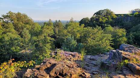
Photo
Where is located Mills Reservation County Park
Mills Reservation County Park — local attraction, which is located at Normal Ave &, Reservoir Dr, Cedar Grove, NJ 07009, United States and belongs to the category — park. Average visitor rating for this place — 4.7 (according to 380 ratings, information from open sources and relevant for 2022).
Exact location — Mills Reservation County Park, marked on the map with a red marker.
You can get directions to Mills Reservation County Park on the map from your location.
What else is interesting in Paterson? You can see all the sights if you go to the city page.
Coordinates
Mills Reservation County Park, United States coordinates in decimal format: latitude — 40.853763661404365, longitude — -74.20989107504131. When converted to degrees, minutes, seconds Mills Reservation County Park has the following coordinates: 40°51′13.55 north latitude and -74°12′35.61 east longitude.
Nearby cities
The largest cities that are located nearby:
- Newark — 20 km
- Yonkers — 23 km
- New York — 26 km
- Elizabeth — 28 km
- Brooklyn — 29 km
- Edison — 48 km
- Stamford — 55 km
- Bridgeport — 87 km
- Toms River — 106 km
- New Haven — 112 km
- Allentown — 116 km
- Waterbury — 117 km
- Philadelphia — 136 km
- Hartford — 154 km
- Springfield — 184 km
- Amherst — 209 km
- Worcester — 244 km
- Providence — 248 km
- Baltimore — 276 km
Distance to the capital
Distance to the capital (Washington) is about — 324 km.