 Warner Robins
Wantagh
Bethel
Misty Hill Farm
United States
Wakonda Beach (R33) Airport
Wilmington
Poland
Miami International Airport
Warner Robins
Wantagh
Bethel
Misty Hill Farm
United States
Wakonda Beach (R33) Airport
Wilmington
Poland
Miami International Airport
Lake County Historical Society on the map, Mentor, United States
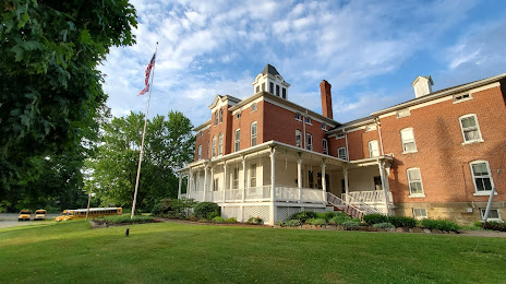
Photo
Where is located Lake County Historical Society
Lake County Historical Society — local attraction, which is located at 415 Riverside Dr, Painesville, OH 44077, United States and belongs to the category — historical society. Average visitor rating for this place — 4.6 (according to 31 rating, information from open sources and relevant for 2022).
Exact location — Lake County Historical Society, marked on the map with a red marker.
You can get directions to Lake County Historical Society on the map from your location.
What else is interesting in Mentor? You can see all the sights if you go to the city page.
Coordinates
Lake County Historical Society, United States coordinates in decimal format: latitude — 41.715877940633945, longitude — -81.22245737501456. When converted to degrees, minutes, seconds Lake County Historical Society has the following coordinates: 41°42′57.16 north latitude and -81°13′20.85 east longitude.
Nearby cities
The largest cities that are located nearby:
- Cleveland — 35 km
- Aurora — 39 km
- Akron — 66 km
- London
 (Canada) — 146 km
 - Windsor (Canada) — 156 km
- Detroit — 158 km
- Warren — 166 km
- Sterling Heights — 171 km
- Pittsburgh — 176 km
- Toledo — 183 km
- Cambridge (Canada) — 205 km
- Kitchener (Canada) — 205 km
- Ann Arbor — 208 km
- Waterloo (Canada) — 209 km
- Hamilton (Canada) — 212 km
- Burlington (Canada) — 221 km
- Guelph (Canada) — 225 km
- Columbus — 235 km
- Saint Catharines (Canada) — 236 km
Distance to the capital
Distance to the capital (Washington) is about — 473 km.