 Warner Robins
Wantagh
Bethel
Misty Hill Farm
United States
Wakonda Beach (R33) Airport
Wilmington
Poland
Miami International Airport
Warner Robins
Wantagh
Bethel
Misty Hill Farm
United States
Wakonda Beach (R33) Airport
Wilmington
Poland
Miami International Airport
Link Centre on the map, Tupelo, United States
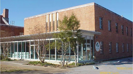
Photo
Where is located Link Centre
Link Centre — local attraction, which is located at 1800 Main St, Tupelo, MS 38801, United States and belongs to the category — arts organization. Average visitor rating for this place — 4.6 (according to 93 ratings, information from open sources and relevant for 2022).
Exact location — Link Centre, marked on the map with a red marker.
You can get directions to Link Centre on the map from your location.
What else is interesting in Tupelo? You can see all the sights if you go to the city page.
Coordinates
Link Centre, United States coordinates in decimal format: latitude — 34.256674076169794, longitude — -88.73446137523015. When converted to degrees, minutes, seconds Link Centre has the following coordinates: 34°15′24.03 north latitude and -88°44′4.06 east longitude.
Nearby cities
The largest cities that are located nearby:
- Memphis — 157 km
- Birmingham — 193 km
- Huntsville — 199 km
- Jackson — 257 km
- Nashville — 272 km
- Clarksville — 278 km
- Montgomery — 307 km
- Chattanooga — 319 km
- Little Rock — 330 km
- Mobile — 399 km
- Atlanta — 401 km
- Evansville — 422 km
- Knoxville — 468 km
- Baton Rouge — 480 km
- Metairie — 492 km
- New Orleans — 494 km
- Saint Louis — 500 km
- Shreveport — 508 km
- Louisville — 510 km
Distance to the capital
Distance to the capital (Washington) is about — 1165 km.