 Warner Robins
Wantagh
Bethel
Misty Hill Farm
United States
Wakonda Beach (R33) Airport
Wilmington
Poland
Miami International Airport
Warner Robins
Wantagh
Bethel
Misty Hill Farm
United States
Wakonda Beach (R33) Airport
Wilmington
Poland
Miami International Airport
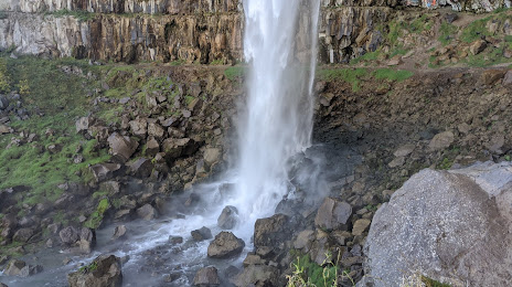
Perrine Coulee Falls on the map, Twin Falls, United States
Photo
Where is located Perrine Coulee Falls
Perrine Coulee Falls — local attraction, which is located at no data and belongs to the category — -. Average visitor rating for this place — 4.7 (according to 65 ratings, information from open sources and relevant for 2022).
Exact location — Perrine Coulee Falls, marked on the map with a red marker.
You can get directions to Perrine Coulee Falls on the map from your location.
What else is interesting in Twin Falls? You can see all the sights if you go to the city page.
Coordinates
Perrine Coulee Falls, United States coordinates in decimal format: latitude — 42.59629069196331, longitude — -114.47305381068878. When converted to degrees, minutes, seconds Perrine Coulee Falls has the following coordinates: 42°35′46.65 north latitude and -114°28′22.99 east longitude.
Nearby cities
The largest cities that are located nearby:
- Boise — 183 km
- West Valley City — 292 km
- Salt Lake City — 293 km
- West Jordan — 302 km
- Provo — 350 km
- Reno — 566 km
- Spokane — 605 km
- Eugene — 705 km
- North Las Vegas — 706 km
- Las Vegas — 709 km
- Portland — 716 km
- Spring Valley — 717 km
- Vancouver — 719 km
- Salem — 721 km
- Henderson — 723 km
- Roseville — 724 km
- Sacramento — 751 km
- Stockton — 783 km
- Modesto — 790 km
Distance to the capital
Distance to the capital (Washington) is about — 3155 km.