
 Bel-Ha
San Jose El Alto
El Porvenir
Nueva Palestina
Santa Lucía
Chemax
La Morita
Temoac
Zacualpan
Bel-Ha
San Jose El Alto
El Porvenir
Nueva Palestina
Santa Lucía
Chemax
La Morita
Temoac
Zacualpan
Z.A. de Cuyuxquihui on the map, Papantla de Olarte, Mexico
Photo
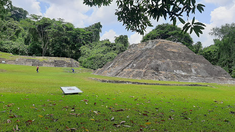
Where is located Z.A. de Cuyuxquihui
Z.A. de Cuyuxquihui — local attraction, which is located at 93538 Veracruz, Mexico and belongs to the category — archaeological site. Average visitor rating for this place — 4.4 (according to 25 ratings, information from open sources and relevant for 2022).
Exact location — Z.A. de Cuyuxquihui, marked on the map with a red marker.
You can get directions to Z.A. de Cuyuxquihui on the map from your location.
What else is interesting in Papantla de Olarte? You can see all the sights if you go to the city page.
Coordinates
Z.A. de Cuyuxquihui, Mexico coordinates in decimal format: latitude — 20.31317250919512, longitude — -97.25477457552981. When converted to degrees, minutes, seconds Z.A. de Cuyuxquihui has the following coordinates: 20°18′47.42 north latitude and -97°15′17.19 east longitude.
Nearby cities
The largest cities that are located nearby:
- Poza Rica de Hidalgo — 17 km
- Martínez de la Torre — 51 km
- Xalapa — 109 km
- Tulancingo — 115 km
- Tantoyuca — 137 km
- Pachuca — 154 km
- Córdoba — 178 km
- Orizaba — 178 km
- Puebla — 180 km
- Texcoco — 193 km
- Ojo de Agua — 197 km
- Ecatepec — 202 km
- Chimalhuacan — 204 km
- Tampico — 205 km
- Ixtapaluca — 205 km
- Coacalco — 206 km
- Ciudad Madero — 206 km
- Ciudad Nezahualcóyotl — 208 km
- Chalco de Díaz Covarrubias — 210 km
Distance to the capital
Distance to the capital (Mexico City) is about — 220 km.