
 Bel-Ha
San Jose El Alto
El Porvenir
Nueva Palestina
Santa Lucía
Chemax
La Morita
Temoac
Zacualpan
Bel-Ha
San Jose El Alto
El Porvenir
Nueva Palestina
Santa Lucía
Chemax
La Morita
Temoac
Zacualpan
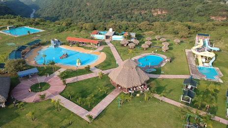
Parque Acuatico El Palmar on the map, Tonalá, Mexico
Photo
Where is located Parque Acuatico El Palmar
Parque Acuatico El Palmar — local attraction, which is located at Calle San Juan 14 Col. El Vado, 45429 Tonalá, Jal., Mexico and belongs to the category — aquatic centre. Average visitor rating for this place — 4.1 (according to 477 ratings, information from open sources and relevant for 2022).
Exact location — Parque Acuatico El Palmar, marked on the map with a red marker.
You can get directions to Parque Acuatico El Palmar on the map from your location.
What else is interesting in Tonalá? You can see all the sights if you go to the city page.
Coordinates
Parque Acuatico El Palmar, Mexico coordinates in decimal format: latitude — 20.603085794421112, longitude — -103.14987307552506. When converted to degrees, minutes, seconds Parque Acuatico El Palmar has the following coordinates: 20°36′11.11 north latitude and -103°8′59.54 east longitude.
Nearby cities
The largest cities that are located nearby:
- Tlaquepaque — 8 km
- Guadalajara — 12 km
- Zapopan — 19 km
- Zamora — 122 km
- Colima — 161 km
- León — 170 km
- Aguascalientes — 170 km
- Uruapan — 184 km
- Irapuato — 195 km
- Tepic — 196 km
- Manzanillo — 203 km
- Puerto Vallarta — 205 km
- Salamanca — 211 km
- Morelia — 236 km
- Zacatecas — 247 km
- Celaya — 252 km
- Fresnillo — 285 km
- San Luis Potosi — 286 km
- Soledad de Graciano Sánchez — 292 km
Distance to the capital
Distance to the capital (Mexico City) is about — 439 km.