 Warner Robins
Wantagh
Bethel
Misty Hill Farm
United States
Wakonda Beach (R33) Airport
Wilmington
Poland
Miami International Airport
Warner Robins
Wantagh
Bethel
Misty Hill Farm
United States
Wakonda Beach (R33) Airport
Wilmington
Poland
Miami International Airport
Historical Society of Marshall County on the map, Marshalltown, United States
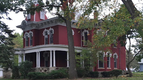
Photo
Where is located Historical Society of Marshall County
Historical Society of Marshall County — local attraction, which is located at 503 W Main St, Marshalltown, IA 50158, United States and belongs to the category — historical society. Average visitor rating for this place — 3.7 (according to 3 ratings, information from open sources and relevant for 2022).
Exact location — Historical Society of Marshall County, marked on the map with a red marker.
You can get directions to Historical Society of Marshall County on the map from your location.
What else is interesting in Marshalltown? You can see all the sights if you go to the city page.
Coordinates
Historical Society of Marshall County, United States coordinates in decimal format: latitude — 42.049459744827814, longitude — -92.92167827509863. When converted to degrees, minutes, seconds Historical Society of Marshall County has the following coordinates: 42°2′58.06 north latitude and -92°55′18.04 east longitude.
Nearby cities
The largest cities that are located nearby:
- Des Moines — 76 km
- Omaha — 272 km
- Madison — 305 km
- Rockford — 313 km
- Peoria — 316 km
- Saint Paul — 321 km
- Minneapolis — 325 km
- Lincoln — 344 km
- Sioux Falls — 348 km
- North Kansas City — 352 km
- Independence — 352 km
- Kansas City — 356 km
- Overland Park — 371 km
- Aurora — 380 km
- Olathe — 387 km
- Naperville — 394 km
- Joliet — 404 km
- Topeka — 408 km
- Milwaukee — 419 km
Distance to the capital
Distance to the capital (Washington) is about — 1386 km.