
 Maureville
Samoëns
Gréning
Toulouse
Volx
Goudet
Méhoncourt
Saint-Hymer
Pontcarré
Maureville
Samoëns
Gréning
Toulouse
Volx
Goudet
Méhoncourt
Saint-Hymer
Pontcarré
Park Reynerie (Parc de la Reynerie) on the map, Toulouse, France
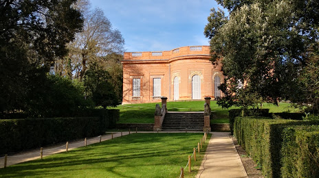
Photo
Where is located Park Reynerie (Parc de la Reynerie)
Park Reynerie (Parc de la Reynerie) — local attraction, which is located at Imp. Abbé Salvat, 31000 Toulouse, France and belongs to the category — park. Average visitor rating for this place — 3.9 (according to 461 rating, information from open sources and relevant for 2022).
Exact location — Park Reynerie (Parc de la Reynerie), marked on the map with a red marker.
You can get directions to Park Reynerie (Parc de la Reynerie) on the map from your location.
What else is interesting in Toulouse? You can see all the sights if you go to the city page.
Coordinates
Park Reynerie (Parc de la Reynerie), France coordinates in decimal format: latitude — 43.57138701306198, longitude — 1.3997873249499448. When converted to degrees, minutes, seconds Park Reynerie (Parc de la Reynerie) has the following coordinates: 43°34′16.99 north latitude and 1°23′59.23 east longitude.
Nearby cities
The largest cities that are located nearby:
- Perpignan — 155 km
- Montpellier — 195 km
- Bordeaux — 209 km
- Lleida
 (Spain) — 230 km
 - Terrassa (Spain) — 230 km
- Nimes — 234 km
- Sabadell (Spain) — 234 km
- Mataró (Spain) — 243 km
- Limoges — 247 km
- Santa Coloma de Gramenet (Spain) — 247 km
- Badalona (Spain) — 248 km
- L'Hospitalet de Llobregat (Spain) — 254 km
- Pamplona (Spain) — 265 km
- Clermont-Ferrand — 272 km
- Tarragona (Spain) — 275 km
- San Sebastián (Spain) — 277 km
- Zaragoza (Spain) — 290 km
- Saint-Étienne — 305 km
- Marseille — 318 km
Distance to the capital
Distance to the capital (Paris) is about — 592 km.