
 Maureville
Samoëns
Gréning
Toulouse
Volx
Goudet
Méhoncourt
Saint-Hymer
Pontcarré
Maureville
Samoëns
Gréning
Toulouse
Volx
Goudet
Méhoncourt
Saint-Hymer
Pontcarré
St. Pierre Park (Parc Saint-Pierre) on the map, Amiens, France
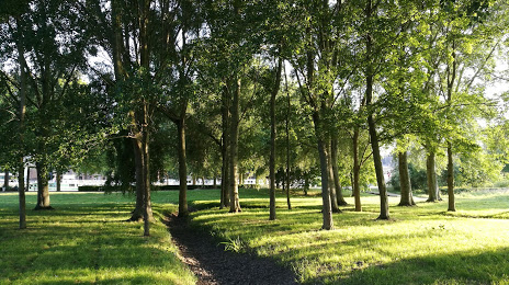
Photo
Where is located St. Pierre Park (Parc Saint-Pierre)
St. Pierre Park (Parc Saint-Pierre) — local attraction, which is located at 80000 Amiens, France and belongs to the category — city park. Average visitor rating for this place — 4.3 (according to 4606 ratings, information from open sources and relevant for 2022).
Exact location — St. Pierre Park (Parc Saint-Pierre), marked on the map with a red marker.
You can get directions to St. Pierre Park (Parc Saint-Pierre) on the map from your location.
What else is interesting in Amiens? You can see all the sights if you go to the city page.
Coordinates
St. Pierre Park (Parc Saint-Pierre), France coordinates in decimal format: latitude — 49.89898272520336, longitude — 2.3079523251663336. When converted to degrees, minutes, seconds St. Pierre Park (Parc Saint-Pierre) has the following coordinates: 49°53′56.34 north latitude and 2°18′28.63 east longitude.
Nearby cities
The largest cities that are located nearby:
- Lille — 97 km
- Rouen — 99 km
- Boulogne-Billancourt — 117 km
- Reims — 144 km
- Charleroi
 (Belgium) — 162 km
 - Le Havre — 163 km
- Eastbourne
 (United Kingdom) — 170 km
 - Brussels (Belgium) — 178 km
- Namur (Belgium) — 192 km
- Gillingham (United Kingdom) — 204 km
- Antwerp (Belgium) — 207 km
- Caen — 208 km
- Southend-on-Sea (United Kingdom) — 213 km
- Crawley (United Kingdom) — 219 km
- Orléans — 222 km
- Basildon (United Kingdom) — 224 km
- Sutton (United Kingdom) — 236 km
- Chelmsford (United Kingdom) — 239 km
- London (United Kingdom) — 244 km
Distance to the capital
Distance to the capital (Paris) is about — 116 km.