
 Maureville
Samoëns
Gréning
Toulouse
Volx
Goudet
Méhoncourt
Saint-Hymer
Pontcarré
Maureville
Samoëns
Gréning
Toulouse
Volx
Goudet
Méhoncourt
Saint-Hymer
Pontcarré
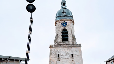
Beffroi d'Amiens on the map, Amiens, France
Photo
Where is located Beffroi d'Amiens
Beffroi d'Amiens — local attraction, which is located at 1 Place Maurice Vast, 80000 Amiens, France and belongs to the category — historical landmark. Average visitor rating for this place — 4.2 (according to 425 ratings, information from open sources and relevant for 2022).
Exact location — Beffroi d'Amiens, marked on the map with a red marker.
You can get directions to Beffroi d'Amiens on the map from your location.
What else is interesting in Amiens? You can see all the sights if you go to the city page.
Coordinates
Beffroi d'Amiens, France coordinates in decimal format: latitude — 49.89538462262627, longitude — 2.2959246251662067. When converted to degrees, minutes, seconds Beffroi d'Amiens has the following coordinates: 49°53′43.38 north latitude and 2°17′45.33 east longitude.
Nearby cities
The largest cities that are located nearby:
- Lille — 97 km
- Rouen — 99 km
- Boulogne-Billancourt — 117 km
- Reims — 144 km
- Charleroi
 (Belgium) — 162 km
 - Le Havre — 163 km
- Eastbourne
 (United Kingdom) — 170 km
 - Brussels (Belgium) — 178 km
- Namur (Belgium) — 192 km
- Gillingham (United Kingdom) — 204 km
- Antwerp (Belgium) — 207 km
- Caen — 208 km
- Southend-on-Sea (United Kingdom) — 213 km
- Crawley (United Kingdom) — 219 km
- Orléans — 222 km
- Basildon (United Kingdom) — 224 km
- Sutton (United Kingdom) — 236 km
- Chelmsford (United Kingdom) — 239 km
- London (United Kingdom) — 244 km
Distance to the capital
Distance to the capital (Paris) is about — 116 km.