
 Maureville
Samoëns
Gréning
Toulouse
Volx
Goudet
Méhoncourt
Saint-Hymer
Pontcarré
Maureville
Samoëns
Gréning
Toulouse
Volx
Goudet
Méhoncourt
Saint-Hymer
Pontcarré
Palais Saint-Georges Garden (Jardin du Palais Saint-Georges) on the map, Rennes, France
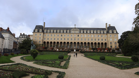
Photo
Where is located Palais Saint-Georges Garden (Jardin du Palais Saint-Georges)
Palais Saint-Georges Garden (Jardin du Palais Saint-Georges) — local attraction, which is located at Rue Kléber, 35000 Rennes, France and belongs to the category — garden. Average visitor rating for this place — 4.6 (according to 206 ratings, information from open sources and relevant for 2022).
Exact location — Palais Saint-Georges Garden (Jardin du Palais Saint-Georges), marked on the map with a red marker.
You can get directions to Palais Saint-Georges Garden (Jardin du Palais Saint-Georges) on the map from your location.
What else is interesting in Rennes? You can see all the sights if you go to the city page.
Coordinates
Palais Saint-Georges Garden (Jardin du Palais Saint-Georges), France coordinates in decimal format: latitude — 48.11109006163355, longitude — -1.6741678748970665. When converted to degrees, minutes, seconds Palais Saint-Georges Garden (Jardin du Palais Saint-Georges) has the following coordinates: 48°6′39.92 north latitude and -1°40′27 east longitude.
Nearby cities
The largest cities that are located nearby:
- Nantes — 100 km
- Angers — 109 km
- Le Mans — 139 km
- Caen — 151 km
- Tours — 194 km
- Le Havre — 199 km
- Brest — 208 km
- Rouen — 248 km
- Orléans — 267 km
- Bournemouth
 (United Kingdom) — 288 km
 - Boulogne-Billancourt — 296 km
- Portsmouth (United Kingdom) — 302 km
- Southampton (United Kingdom) — 309 km
- Exeter (United Kingdom) — 316 km
- Eastbourne (United Kingdom) — 324 km
- Limoges — 339 km
- Amiens — 345 km
- Crawley (United Kingdom) — 347 km
- Reading (United Kingdom) — 372 km
Distance to the capital
Distance to the capital (Paris) is about — 308 km.