
 Maureville
Samoëns
Gréning
Toulouse
Volx
Goudet
Méhoncourt
Saint-Hymer
Pontcarré
Maureville
Samoëns
Gréning
Toulouse
Volx
Goudet
Méhoncourt
Saint-Hymer
Pontcarré
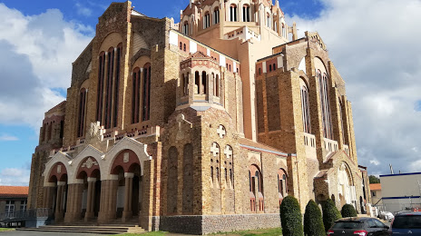
Church of the Sacred Heart on the map, Cholet, France
Photo
Where is located Church of the Sacred Heart
Church of the Sacred Heart — local attraction, which is located at 25 Bd Guy Chouteau, 49300 Cholet, France and belongs to the category — catholic church. Average visitor rating for this place — 4.5 (according to 220 ratings, information from open sources and relevant for 2022).
Exact location — Church of the Sacred Heart, marked on the map with a red marker.
You can get directions to Church of the Sacred Heart on the map from your location.
What else is interesting in Cholet? You can see all the sights if you go to the city page.
Coordinates
Church of the Sacred Heart, France coordinates in decimal format: latitude — 47.066749739654014, longitude — -0.887192974933294. When converted to degrees, minutes, seconds Church of the Sacred Heart has the following coordinates: 47°4′0.3 north latitude and -0°53′13.89 east longitude.
Nearby cities
The largest cities that are located nearby:
- Angers — 52 km
- Nantes — 54 km
- Tours — 123 km
- Rennes — 131 km
- Le Mans — 132 km
- Limoges — 213 km
- Orléans — 227 km
- Caen — 238 km
- Bordeaux — 247 km
- Le Havre — 278 km
- Rouen — 300 km
- Boulogne-Billancourt — 300 km
- Brest — 303 km
- Clermont-Ferrand — 337 km
- Amiens — 386 km
- Bournemouth
 (United Kingdom) — 411 km
 - Portsmouth (United Kingdom) — 416 km
- Eastbourne (United Kingdom) — 418 km
- San Sebastián
 (Spain) — 423 km
Distance to the capital
Distance to the capital (Paris) is about — 313 km.