
 Maureville
Samoëns
Gréning
Toulouse
Volx
Goudet
Méhoncourt
Saint-Hymer
Pontcarré
Maureville
Samoëns
Gréning
Toulouse
Volx
Goudet
Méhoncourt
Saint-Hymer
Pontcarré
Plage de Tourony on the map, Lannion, France
Photo
Where is located Plage de Tourony
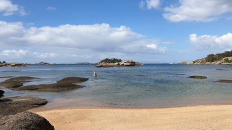
Plage de Tourony — local attraction, which is located at Rue de Tourony, Trégastel, France and belongs to the category — public beach. Average visitor rating for this place — 4.6 (according to 1078 ratings, information from open sources and relevant for 2022).
Exact location — Plage de Tourony, marked on the map with a red marker.
You can get directions to Plage de Tourony on the map from your location.
What else is interesting in Lannion? You can see all the sights if you go to the city page.
Coordinates
Plage de Tourony, France coordinates in decimal format: latitude — 48.8284679645005, longitude — -3.4952529748718293. When converted to degrees, minutes, seconds Plage de Tourony has the following coordinates: 48°49′42.48 north latitude and -3°29′42.91 east longitude.
Nearby cities
The largest cities that are located nearby:
- Brest — 84 km
- Rennes — 148 km
- Exeter
 (United Kingdom) — 220 km
 - Nantes — 220 km
- Caen — 229 km
- Bournemouth (United Kingdom) — 246 km
- Angers — 257 km
- Le Havre — 270 km
- Southampton (United Kingdom) — 280 km
- Le Mans — 282 km
- Portsmouth (United Kingdom) — 284 km
- Bristol (Great Britain) — 307 km
- Swindon (United Kingdom) — 333 km
- Rouen — 337 km
- Tours — 344 km
- Eastbourne (United Kingdom) — 346 km
- Reading (United Kingdom) — 346 km
- Crawley (United Kingdom) — 347 km
- Cheltenham (United Kingdom) — 363 km
Distance to the capital
Distance to the capital (Paris) is about — 428 km.