
 Maureville
Samoëns
Gréning
Toulouse
Volx
Goudet
Méhoncourt
Saint-Hymer
Pontcarré
Maureville
Samoëns
Gréning
Toulouse
Volx
Goudet
Méhoncourt
Saint-Hymer
Pontcarré
Plage du Coz-Pors on the map, Lannion, France
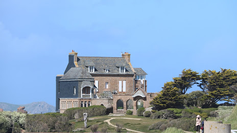
Photo
Where is located Plage du Coz-Pors
Plage du Coz-Pors — local attraction, which is located at Bd du Coz-Pors, 22730 Trégastel, France and belongs to the category — beach pavillion. Average visitor rating for this place — 4.7 (according to 384 ratings, information from open sources and relevant for 2022).
Exact location — Plage du Coz-Pors, marked on the map with a red marker.
You can get directions to Plage du Coz-Pors on the map from your location.
What else is interesting in Lannion? You can see all the sights if you go to the city page.
Coordinates
Plage du Coz-Pors, France coordinates in decimal format: latitude — 48.833118667778756, longitude — -3.5163285748716544. When converted to degrees, minutes, seconds Plage du Coz-Pors has the following coordinates: 48°49′59.23 north latitude and -3°30′58.78 east longitude.
Nearby cities
The largest cities that are located nearby:
- Brest — 84 km
- Rennes — 148 km
- Exeter
 (United Kingdom) — 220 km
 - Nantes — 220 km
- Caen — 229 km
- Bournemouth (United Kingdom) — 246 km
- Angers — 257 km
- Le Havre — 270 km
- Southampton (United Kingdom) — 280 km
- Le Mans — 282 km
- Portsmouth (United Kingdom) — 284 km
- Bristol (Great Britain) — 307 km
- Swindon (United Kingdom) — 333 km
- Rouen — 337 km
- Tours — 344 km
- Eastbourne (United Kingdom) — 346 km
- Reading (United Kingdom) — 346 km
- Crawley (United Kingdom) — 347 km
- Cheltenham (United Kingdom) — 363 km
Distance to the capital
Distance to the capital (Paris) is about — 429 km.