
 Maureville
Samoëns
Gréning
Toulouse
Volx
Goudet
Méhoncourt
Saint-Hymer
Pontcarré
Maureville
Samoëns
Gréning
Toulouse
Volx
Goudet
Méhoncourt
Saint-Hymer
Pontcarré
Parque San Vicente (Parc Sant-Vicens) on the map, Perpignan, France
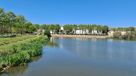
Photo
Where is located Parque San Vicente (Parc Sant-Vicens)
Parque San Vicente (Parc Sant-Vicens) — local attraction, which is located at 66000 Perpignan, France and belongs to the category — park. Average visitor rating for this place — 4.3 (according to 1236 ratings, information from open sources and relevant for 2022).
Exact location — Parque San Vicente (Parc Sant-Vicens), marked on the map with a red marker.
You can get directions to Parque San Vicente (Parc Sant-Vicens) on the map from your location.
What else is interesting in Perpignan? You can see all the sights if you go to the city page.
Coordinates
Parque San Vicente (Parc Sant-Vicens), France coordinates in decimal format: latitude — 42.69133679272476, longitude — 2.9162827250162544. When converted to degrees, minutes, seconds Parque San Vicente (Parc Sant-Vicens) has the following coordinates: 42°41′28.81 north latitude and 2°54′58.62 east longitude.
Nearby cities
The largest cities that are located nearby:
- Montpellier — 129 km
- Mataró
 (Spain) — 133 km
 - Sabadell (Spain) — 142 km
- Terrassa (Spain) — 144 km
- Badalona (Spain) — 147 km
- Santa Coloma de Gramenet (Spain) — 149 km
- Toulouse — 154 km
- L'Hospitalet de Llobregat (Spain) — 160 km
- Nimes — 173 km
- Marseille — 210 km
- Tarragona (Spain) — 221 km
- Lleida (Spain) — 222 km
- Aix-en-Provence — 225 km
- Toulon — 249 km
- Saint-Étienne — 325 km
- Zaragoza (Spain) — 333 km
- Clermont-Ferrand — 342 km
- Palma (Spain) — 345 km
- Grenoble — 354 km
Distance to the capital
Distance to the capital (Paris) is about — 687 km.