
 Maureville
Samoëns
Gréning
Toulouse
Volx
Goudet
Méhoncourt
Saint-Hymer
Pontcarré
Maureville
Samoëns
Gréning
Toulouse
Volx
Goudet
Méhoncourt
Saint-Hymer
Pontcarré
Fort du Serrat d'en Vaquer on the map, Perpignan, France
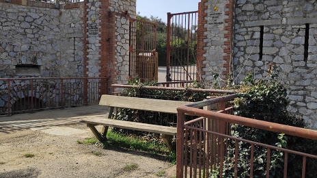
Photo
Where is located Fort du Serrat d'en Vaquer
Fort du Serrat d'en Vaquer — local attraction, which is located at Av. Charles Deperet, 66000 Perpignan, France and belongs to the category — park. Average visitor rating for this place — 3.9 (according to 96 ratings, information from open sources and relevant for 2022).
Exact location — Fort du Serrat d'en Vaquer, marked on the map with a red marker.
You can get directions to Fort du Serrat d'en Vaquer on the map from your location.
What else is interesting in Perpignan? You can see all the sights if you go to the city page.
Coordinates
Fort du Serrat d'en Vaquer, France coordinates in decimal format: latitude — 42.67243788192979, longitude — 2.8785349250156287. When converted to degrees, minutes, seconds Fort du Serrat d'en Vaquer has the following coordinates: 42°40′20.78 north latitude and 2°52′42.73 east longitude.
Nearby cities
The largest cities that are located nearby:
- Montpellier — 129 km
- Mataró
 (Spain) — 133 km
 - Sabadell (Spain) — 142 km
- Terrassa (Spain) — 144 km
- Badalona (Spain) — 147 km
- Santa Coloma de Gramenet (Spain) — 149 km
- Toulouse — 154 km
- L'Hospitalet de Llobregat (Spain) — 160 km
- Nimes — 173 km
- Marseille — 210 km
- Tarragona (Spain) — 221 km
- Lleida (Spain) — 222 km
- Aix-en-Provence — 225 km
- Toulon — 249 km
- Saint-Étienne — 325 km
- Zaragoza (Spain) — 333 km
- Clermont-Ferrand — 342 km
- Palma (Spain) — 345 km
- Grenoble — 354 km
Distance to the capital
Distance to the capital (Paris) is about — 689 km.