
 Maureville
Samoëns
Gréning
Toulouse
Volx
Goudet
Méhoncourt
Saint-Hymer
Pontcarré
Maureville
Samoëns
Gréning
Toulouse
Volx
Goudet
Méhoncourt
Saint-Hymer
Pontcarré
Temple Saint-Éloi on the map, Mont-Saint-Aignan, France
Photo
Where is located Temple Saint-Éloi
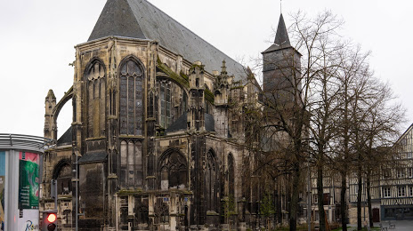
Temple Saint-Éloi — local attraction, which is located at 20 Pl. Martin Luther King, 76000 Rouen, France and belongs to the category — protestant church. Average visitor rating for this place — 4.2 (according to 86 ratings, information from open sources and relevant for 2022).
Exact location — Temple Saint-Éloi, marked on the map with a red marker.
You can get directions to Temple Saint-Éloi on the map from your location.
What else is interesting in Mont-Saint-Aignan? You can see all the sights if you go to the city page.
Coordinates
Temple Saint-Éloi, France coordinates in decimal format: latitude — 49.44174719879926, longitude — 1.0872584980616165. When converted to degrees, minutes, seconds Temple Saint-Éloi has the following coordinates: 49°26′30.29 north latitude and 1°5′14.13 east longitude.
Nearby cities
The largest cities that are located nearby:
- Rouen — 2 km
- Le Havre — 70 km
- Amiens — 99 km
- Boulogne-Billancourt — 109 km
- Caen — 109 km
- Eastbourne
 (United Kingdom) — 155 km
 - Le Mans — 173 km
- Orléans — 183 km
- Lille — 190 km
- Crawley (United Kingdom) — 202 km
- Portsmouth (United Kingdom) — 213 km
- Reims — 214 km
- Gillingham (United Kingdom) — 216 km
- Sutton (United Kingdom) — 228 km
- Tours — 230 km
- Southend-on-Sea (United Kingdom) — 232 km
- Southampton (United Kingdom) — 236 km
- Basildon (United Kingdom) — 237 km
- London (United Kingdom) — 241 km
Distance to the capital
Distance to the capital (Paris) is about — 113 km.