
 Maureville
Samoëns
Gréning
Toulouse
Volx
Goudet
Méhoncourt
Saint-Hymer
Pontcarré
Maureville
Samoëns
Gréning
Toulouse
Volx
Goudet
Méhoncourt
Saint-Hymer
Pontcarré
Amphithéâtre romain de Toulouse-Purpan on the map, Blagnac, France
Photo
Where is located Amphithéâtre romain de Toulouse-Purpan
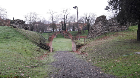
Amphithéâtre romain de Toulouse-Purpan — local attraction, which is located at Rue de Purpan, 31300 Toulouse, France and belongs to the category — historical landmark. Average visitor rating for this place — 3.8 (according to 125 ratings, information from open sources and relevant for 2022).
Exact location — Amphithéâtre romain de Toulouse-Purpan, marked on the map with a red marker.
You can get directions to Amphithéâtre romain de Toulouse-Purpan on the map from your location.
What else is interesting in Blagnac? You can see all the sights if you go to the city page.
Coordinates
Amphithéâtre romain de Toulouse-Purpan, France coordinates in decimal format: latitude — 43.61503624123991, longitude — 1.3975706978630278. When converted to degrees, minutes, seconds Amphithéâtre romain de Toulouse-Purpan has the following coordinates: 43°36′54.13 north latitude and 1°23′51.25 east longitude.
Nearby cities
The largest cities that are located nearby:
- Toulouse — 5 km
- Perpignan — 161 km
- Montpellier — 199 km
- Bordeaux — 204 km
- Lleida
 (Spain) — 232 km
 - Terrassa (Spain) — 235 km
- Nimes — 237 km
- Sabadell (Spain) — 238 km
- Limoges — 243 km
- Mataró (Spain) — 248 km
- Santa Coloma de Gramenet (Spain) — 251 km
- Badalona (Spain) — 252 km
- L'Hospitalet de Llobregat (Spain) — 258 km
- Pamplona (Spain) — 263 km
- Clermont-Ferrand — 270 km
- San Sebastián (Spain) — 274 km
- Tarragona (Spain) — 278 km
- Zaragoza (Spain) — 290 km
- Saint-Étienne — 306 km
Distance to the capital
Distance to the capital (Paris) is about — 588 km.