
 Maureville
Samoëns
Gréning
Toulouse
Volx
Goudet
Méhoncourt
Saint-Hymer
Pontcarré
Maureville
Samoëns
Gréning
Toulouse
Volx
Goudet
Méhoncourt
Saint-Hymer
Pontcarré
Château de Taillebourg on the map, Saintes, France
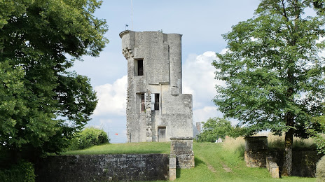
Photo
Where is located Château de Taillebourg
Château de Taillebourg — local attraction, which is located at 17350 Taillebourg, France and belongs to the category — castle. Average visitor rating for this place — 4.1 (according to 98 ratings, information from open sources and relevant for 2022).
Exact location — Château de Taillebourg, marked on the map with a red marker.
You can get directions to Château de Taillebourg on the map from your location.
What else is interesting in Saintes? You can see all the sights if you go to the city page.
Coordinates
Château de Taillebourg, France coordinates in decimal format: latitude — 45.834972903751364, longitude — -0.6470043020635923. When converted to degrees, minutes, seconds Château de Taillebourg has the following coordinates: 45°50′5.9 north latitude and -0°38′49.22 east longitude.
Nearby cities
The largest cities that are located nearby:
- Bordeaux — 100 km
- Limoges — 146 km
- Nantes — 177 km
- Angers — 192 km
- Tours — 207 km
- Le Mans — 258 km
- Rennes — 273 km
- Clermont-Ferrand — 287 km
- Toulouse — 289 km
- San Sebastián
 (Spain) — 289 km
 - Orléans — 304 km
- Bilbao (Spain) — 331 km
- Pamplona (Spain) — 334 km
- Santander (Spain) — 359 km
- Vitoria-Gasteiz (Spain) — 360 km
- Caen — 381 km
- Saint-Étienne — 391 km
- Logroño (Spain) — 392 km
- Boulogne-Billancourt — 401 km
Distance to the capital
Distance to the capital (Paris) is about — 405 km.