
 Maureville
Samoëns
Gréning
Toulouse
Volx
Goudet
Méhoncourt
Saint-Hymer
Pontcarré
Maureville
Samoëns
Gréning
Toulouse
Volx
Goudet
Méhoncourt
Saint-Hymer
Pontcarré
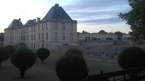
Château du DOUHET - Privé - on the map, Saintes, France
Photo
Where is located Château du DOUHET - Privé -
Château du DOUHET - Privé - — local attraction, which is located at Unnamed Road, 17100 Le Douhet, France and belongs to the category — castle. Average visitor rating for this place — 4.0 (according to 21 rating, information from open sources and relevant for 2022).
Exact location — Château du DOUHET - Privé -, marked on the map with a red marker.
You can get directions to Château du DOUHET - Privé - on the map from your location.
What else is interesting in Saintes? You can see all the sights if you go to the city page.
Coordinates
Château du DOUHET - Privé -, France coordinates in decimal format: latitude — 45.82120969450862, longitude — -0.5671955020640489. When converted to degrees, minutes, seconds Château du DOUHET - Privé - has the following coordinates: 45°49′16.35 north latitude and -0°34′1.9 east longitude.
Nearby cities
The largest cities that are located nearby:
- Bordeaux — 100 km
- Limoges — 146 km
- Nantes — 177 km
- Angers — 192 km
- Tours — 207 km
- Le Mans — 258 km
- Rennes — 273 km
- Clermont-Ferrand — 287 km
- Toulouse — 289 km
- San Sebastián
 (Spain) — 289 km
 - Orléans — 304 km
- Bilbao (Spain) — 331 km
- Pamplona (Spain) — 334 km
- Santander (Spain) — 359 km
- Vitoria-Gasteiz (Spain) — 360 km
- Caen — 381 km
- Saint-Étienne — 391 km
- Logroño (Spain) — 392 km
- Boulogne-Billancourt — 401 km
Distance to the capital
Distance to the capital (Paris) is about — 403 km.