
 Maureville
Samoëns
Gréning
Toulouse
Volx
Goudet
Méhoncourt
Saint-Hymer
Pontcarré
Maureville
Samoëns
Gréning
Toulouse
Volx
Goudet
Méhoncourt
Saint-Hymer
Pontcarré
Musée d'Art et d'Industrie on the map, Saint-Étienne, France
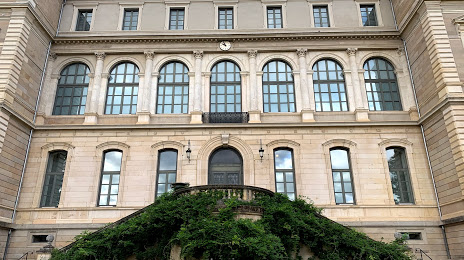
Photo
Where is located Musée d'Art et d'Industrie
Musée d'Art et d'Industrie — local attraction, which is located at 2 Pl. Louis Comte, 42000 Saint-Étienne, France and belongs to the category — heritage museum. Average visitor rating for this place — 4.4 (according to 495 ratings, information from open sources and relevant for 2022).
Exact location — Musée d'Art et d'Industrie, marked on the map with a red marker.
You can get directions to Musée d'Art et d'Industrie on the map from your location.
What else is interesting in Saint-Étienne? You can see all the sights if you go to the city page.
Coordinates
Musée d'Art et d'Industrie, France coordinates in decimal format: latitude — 45.421614708952355, longitude — 4.366456826590078. When converted to degrees, minutes, seconds Musée d'Art et d'Industrie has the following coordinates: 45°25′17.81 north latitude and 4°21′59.24 east longitude.
Nearby cities
The largest cities that are located nearby:
- Lyon — 50 km
- Villeurbanne — 53 km
- Clermont-Ferrand — 107 km
- Grenoble — 108 km
- Geneva
 (Switzerland) — 158 km
 - Nimes — 177 km
- Montpellier — 206 km
- Lausanne (Switzerland) — 209 km
- Dijon — 214 km
- Aix-en-Provence — 228 km
- Besançon — 234 km
- Limoges — 245 km
- Marseille — 250 km
- Turin
 (Italy) — 261 km
 - Toulon — 285 km
- Bern (Switzerland) — 285 km
- Nice — 299 km
- Toulouse — 311 km
- Perpignan — 327 km
Distance to the capital
Distance to the capital (Paris) is about — 411 km.