
 Maureville
Samoëns
Gréning
Toulouse
Volx
Goudet
Méhoncourt
Saint-Hymer
Pontcarré
Maureville
Samoëns
Gréning
Toulouse
Volx
Goudet
Méhoncourt
Saint-Hymer
Pontcarré
Château de la Moglais on the map, Lamballe, France
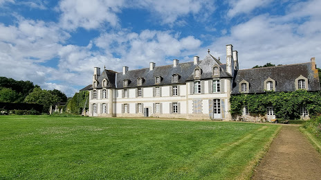
Photo
Where is located Château de la Moglais
Château de la Moglais — local attraction, which is located at 22400 Lamballe, France and belongs to the category — castle. Average visitor rating for this place — 4.9 (according to 14 ratings, information from open sources and relevant for 2022).
Exact location — Château de la Moglais, marked on the map with a red marker.
You can get directions to Château de la Moglais on the map from your location.
What else is interesting in Lamballe? You can see all the sights if you go to the city page.
Coordinates
Château de la Moglais, France coordinates in decimal format: latitude — 48.4697724123638, longitude — -2.4850320019728125. When converted to degrees, minutes, seconds Château de la Moglais has the following coordinates: 48°28′11.18 north latitude and -2°29′6.12 east longitude.
Nearby cities
The largest cities that are located nearby:
- Rennes — 73 km
- Brest — 145 km
- Nantes — 156 km
- Caen — 174 km
- Angers — 183 km
- Le Mans — 207 km
- Le Havre — 220 km
- Bournemouth
 (United Kingdom) — 253 km
 - Exeter (United Kingdom) — 259 km
- Tours — 268 km
- Portsmouth (United Kingdom) — 278 km
- Southampton (United Kingdom) — 281 km
- Rouen — 281 km
- Eastbourne (United Kingdom) — 321 km
- Bristol (Great Britain) — 330 km
- Crawley (United Kingdom) — 334 km
- Orléans — 334 km
- Swindon (United Kingdom) — 345 km
- Reading (United Kingdom) — 347 km
Distance to the capital
Distance to the capital (Paris) is about — 358 km.