
 Donchery
Ronchin
Trizay
Combourg
Sévrier
Cargèse
Vesoul
Épône
Aix-en-Provence
Saint-Lô
Grigny
Sedan
Grasse
Le Tréport
Tournus
Biesheim
Scionzier
Chantilly
Creil
Donchery
Ronchin
Trizay
Combourg
Sévrier
Cargèse
Vesoul
Épône
Aix-en-Provence
Saint-Lô
Grigny
Sedan
Grasse
Le Tréport
Tournus
Biesheim
Scionzier
Chantilly
Creil
Lamballe on the map, France
Where is located Lamballe
Exact location — Lamballe, Cotes-d'Armor, Brittany, France, marked on the map with a red marker.
Coordinates
Lamballe, France coordinates in decimal format: latitude — 48.468637, longitude — -2.517322. When converted to degrees, minutes, seconds Lamballe has the following coordinates: 48°28′7.09 north latitude and -2°31′2.36 east longitude.
Population
Lamballe, Cotes-d'Armor, Brittany, France, according to our data the population is — 11,085 residents, which is about 0% of the total population of the country (France).
Comparison of the population on the graph:
Exact time
Time zone for this location Lamballe — UTC +2 Europe/Paris. Exact time — thursday, 5 may 2024 year, 16 h. 24 minutes.
Sunrise and sunset
Lamballe, sunrise and sunset data for a date — thursday 9.05.2024.
| Sunrise | Sunset | Day (duration) |
|---|---|---|
| 06:40 -2 minutes | 21:32 +2 minutes | 14 h. 54 minutes. +4 minutes |
You can control the scale of the map using the auxiliary tools to find out exactly where it is located Lamballe. When you change the scale of the map, the width of the ruler also changes (in kilometers and miles).
Nearby cities
The largest cities that are located nearby:
- Rennes — 73 km
- Brest — 145 km
- Nantes — 156 km
- Caen — 174 km
- Angers — 183 km
- Le Mans — 207 km
- Le Havre — 220 km
- Bournemouth
 (United Kingdom) — 253 km
 - Exeter (United Kingdom) — 259 km
- Tours — 268 km
- Portsmouth (United Kingdom) — 278 km
- Southampton (United Kingdom) — 281 km
- Rouen — 281 km
- Eastbourne (United Kingdom) — 321 km
- Bristol (Great Britain) — 330 km
- Crawley (United Kingdom) — 334 km
- Orléans — 334 km
- Swindon (United Kingdom) — 345 km
- Reading (United Kingdom) — 347 km
Distance to neighboring capitals:
- London (United Kingdom) — 379 km
- Brussels
 (Belgium) — 561 km
 - Amsterdam
 (Netherlands) — 681 km
 - Andorra la Vella
 (Andorra) — 734 km
 - Bern
 (Switzerland) — 764 km
 - Madrid
 (Spain) — 900 km
 - Vaduz
 (Liechtenstein) — 910 km
 - Lisbon
 (Portugal) — 1207 km
 - Berlin
 (Germany) — 1210 km
 - Prague
 (Czech Republic) — 1241 km
 - Copenhagen
 (Denmark) — 1302 km
 - Rome
 (Italy) — 1381 km
 - Vienna
 (Austria) — 1393 km
 - Warsaw
 (Poland) — 1713 km
 - Nicosia
 — 3282 km
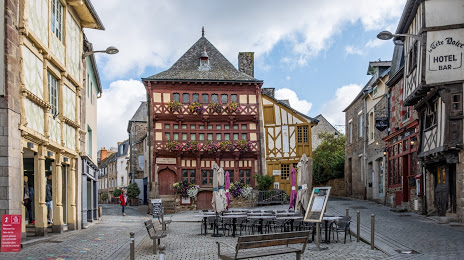
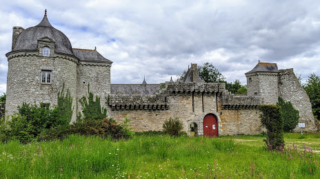
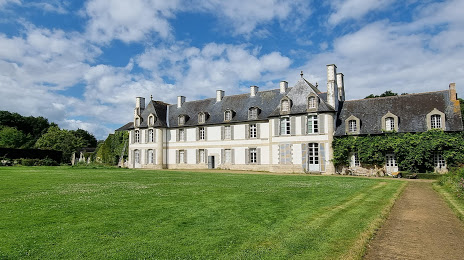
Attractions


Distance to the capital
Distance to the capital (Paris) is about — 360 km.