Dickson City — Midway Airport
Dickson City — Staples Township
Dickson City — Darwin
Dickson City — Trego
Dickson City — Glenford
Dickson City — Naoma
Dickson City — Robertsville
Dickson City — Imnaha
Dickson City — Indiantown
Dickson City — Kerrville
Dickson City — Twin-Oaks Airport
Dickson City — Prairie View
Dickson City — Kenduskeag
Dickson City — Bonnie
Dickson City — Ordway
Dickson City — North Falmouth
Dickson City — Wheeler Airport
Dickson City — Calhoun County
Dickson City — Reedley
Gouldsboro
Tobyhanna
Pocono Summit
Swiftwater
Tannersville
Stroudsburg
East Stroudsburg
Delaware Water Gap
Mount Bethel
Blairstown
Greendell
Stanhope
Roxbury Township
Mount Arlington
Denville
Parsippany-Troy Hills
Pine Brook
East Hanover
Roseland
Essex County
West Orange
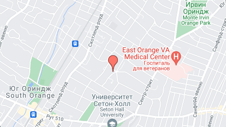
Dickson City — East Orange distance, route on the map
Distance by car
Distance between Dickson City, Pennsylvania, United States and East Orange, New Jersey, United States by car is — km, or miles. To travel this distance by car, you need minute, or h.
Route on the map, driving directions
Car route Dickson City — East Orange was created automatically. The road on the map is shown as a blue line. By moving the markers, you can create a new route through the points you need.
Passing cities through which the car route passes: Dunmore, Gouldsboro, Tobyhanna, Pocono Summit, Swiftwater, Tannersville, Stroudsburg, East Stroudsburg, Delaware Water Gap, Mount Bethel, Blairstown, Greendell, Stanhope, Roxbury Township, Mount Arlington, Denville, Parsippany-Troy Hills, Pine Brook, East Hanover, Roseland, Essex County, West Orange.
Distance by plane
If you decide to take a trip Dickson City East Orange by plane, then you have to fly the distance — 142 km or 88 miles. It is marked on the map with a gray line (between two points in a straight line).
Flight time
Estimated flight time Dickson City East Orange by plane at cruising speed 750 km / h will be — 11 min.
Direction of movement
United States, Dickson City — right-hand traffic. United States, East Orange — right-hand traffic.
Difference in time
Dickson City and East Orange are in the same time zone. Between them there is no time difference (UTC -4 America/New_York).
Interesting Facts
Information on alternative ways to get to your destination.
The length of this distance is about 0.4% of the total length of the equator.
The percentage of the population is clearly shown in the graph:
Dickson City — 5,932 (less by 62,458), East Orange — 68,390 residents.
The cost of travel
Calculate the cost of the trip yourself using the fuel consumption calculator, changing the data in the table.