Ekangala — Uniondale
Ekangala — Ndumu
Ekangala — Pennington
Ekangala — Krugersdorp
Ekangala — Yzerfontein
Ekangala — Zululand DC
Ekangala — Koster
Ekangala — Mpumalanga, KwaZulu-Natal
Ekangala — Lephalale
Ekangala — Newlands
Ekangala — Montagu
Ekangala — Diepkloof
Ekangala — Gansbaai
Ekangala — Reservoir Hills
Ekangala — Thohoyandou
Ekangala — Cornelia
Ekangala — Clocolan
Ekangala — Ashton
Ekangala — Little Falls
Bronkhorstspruit
Rayton
Rayton
Silver Lakes Golf Estate
Silverton
Hatfield
Lynnwood Manor
Menlo Park
Waterkloof Ridge
Wingate Park
Irene
Centurion
Olifantsfontein
Midrand
Halfway House
Morningside
Alexandra
Sandton
Kew
Melrose
Houghton Estate
Parkview
Melville
Johannesburg
Turffontein
Diepkloof
Pimville
Zakariyya Park
Grasmere
Evaton
Sebokeng
ArcelorMittal Vanderbijlpark Works
Parys
Riastuine AH
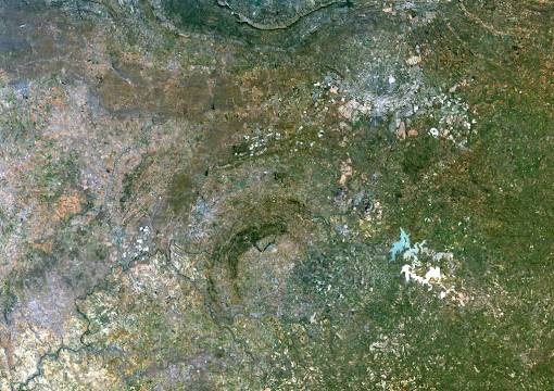
Ekangala — Vredefort distance, route on the map
Distance by car
Distance between Ekangala, Gauteng, South Africa and Vredefort, Free State, South Africa by car is — km, or miles. To travel this distance by car, you need minute, or h.
Route on the map, driving directions
Car route Ekangala — Vredefort was created automatically. The road on the map is shown as a blue line. By moving the markers, you can create a new route through the points you need.
Passing cities through which the car route passes: Bronkhorstspruit, Bronkhorstspruit, Rayton, Rayton, Silver Lakes Golf Estate, Silverton, Hatfield, Lynnwood Manor, Menlo Park, Waterkloof Ridge, Wingate Park, Irene, Centurion, Olifantsfontein, Midrand, Halfway House, Morningside, Alexandra, Sandton, Kew, Melrose, Houghton Estate, Parkview, Melville, Johannesburg, Turffontein, Diepkloof, Pimville, Zakariyya Park, Grasmere, Evaton, Sebokeng, ArcelorMittal Vanderbijlpark Works, Parys, Riastuine AH.
Distance by plane
If you decide to take a trip Ekangala Vredefort by plane, then you have to fly the distance — 200 km or 124 miles. It is marked on the map with a gray line (between two points in a straight line).
Flight time
Estimated flight time Ekangala Vredefort by plane at cruising speed 750 km / h will be — 16 min.
Direction of movement
South Africa, Ekangala — left-hand traffic. South Africa, Vredefort — left-hand traffic.
Difference in time
Ekangala and Vredefort are in the same time zone. Between them there is no time difference (UTC +2 Africa/Johannesburg).
Interesting Facts
Information on alternative ways to get to your destination.
The length of this distance is about 0.5% of the total length of the equator.
The percentage of the population is clearly shown in the graph:
Ekangala — 37,650, Vredefort — 10,649 residents (less by 27,001).
The cost of travel
Calculate the cost of the trip yourself using the fuel consumption calculator, changing the data in the table.