
 Mikhaylovka
Dyrestuy
Mikhaylovka
Mayskiy
Novobessergenevka
Tersky District
Lesnoy
Tertezh
Kuz'minskiye Otverzhki
Mikhaylovka
Dyrestuy
Mikhaylovka
Mayskiy
Novobessergenevka
Tersky District
Lesnoy
Tertezh
Kuz'minskiye Otverzhki
Gorodskoy Krayevedcheskiy Muzey on the map, Komsomolsk-on-Amur, Russian Federation
Photo
Where is located Gorodskoy Krayevedcheskiy Muzey
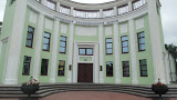
Gorodskoy Krayevedcheskiy Muzey — local attraction, which is located at Ulitsa Kirova, 27, Komsomolsk-on-Amur, Khabarovsk Krai, 681000 and belongs to the category — local history museum. Average visitor rating for this place — 4.6 (according to 123 ratings, information from open sources and relevant for 2022).
Exact location — Gorodskoy Krayevedcheskiy Muzey, marked on the map with a red marker.
You can get directions to Gorodskoy Krayevedcheskiy Muzey on the map from your location.
What else is interesting in Komsomolsk-on-Amur? You can see all the sights if you go to the city page.
Coordinates
Gorodskoy Krayevedcheskiy Muzey, Russian Federation coordinates in decimal format: latitude — 50.54374870406714, longitude — 137.0298310982598. When converted to degrees, minutes, seconds Gorodskoy Krayevedcheskiy Muzey has the following coordinates: 50°32′37.5 north latitude and 137°1′47.39 east longitude.
Nearby cities
The largest cities that are located nearby:
- Khabarovsk — 269 km
- Yuzhno-Sakhalinsk — 588 km
- Hegang
 (China) — 615 km
 - Jiamusi (China) — 655 km
- Blagoveshchensk — 669 km
- Heihe (China) — 671 km
- Jixi (China) — 748 km
- Ussuriysk — 849 km
- Asahikawa
 (Japan) — 865 km
 - Suihua (China) — 876 km
- Otaru (Japan) — 877 km
- Mudanjiang (China) — 883 km
- Artem — 885 km
- Sapporo (Japan) — 901 km
- Ebetsu (Japan) — 903 km
- Vladivostok — 919 km
- Nakhodka — 920 km
- Kitami (Japan) — 928 km
- Tomakomai (Japan) — 954 km
Distance to the capital
Distance to the capital (Moscow) is about — 6069 km.