
 Mikhaylovka
Dyrestuy
Mikhaylovka
Mayskiy
Novobessergenevka
Tersky District
Lesnoy
Tertezh
Kuz'minskiye Otverzhki
Mikhaylovka
Dyrestuy
Mikhaylovka
Mayskiy
Novobessergenevka
Tersky District
Lesnoy
Tertezh
Kuz'minskiye Otverzhki
Park Yantarnogo Perioda. on the map, Svetlogorsk, Russian Federation
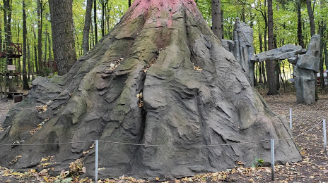
Photo
Where is located Park Yantarnogo Perioda.
Park Yantarnogo Perioda. — local attraction, which is located at Ulitsa Lenina, 27 а, Svetlogorsk, Kaliningrad Oblast, 238560 and belongs to the category — museum. Average visitor rating for this place — 4.6 (according to 634 ratings, information from open sources and relevant for 2022).
Exact location — Park Yantarnogo Perioda., marked on the map with a red marker.
You can get directions to Park Yantarnogo Perioda. on the map from your location.
What else is interesting in Svetlogorsk? You can see all the sights if you go to the city page.
Coordinates
Park Yantarnogo Perioda., Russian Federation coordinates in decimal format: latitude — 54.939408863407714, longitude — 20.116796748424047. When converted to degrees, minutes, seconds Park Yantarnogo Perioda. has the following coordinates: 54°56′21.87 north latitude and 20°7′0.47 east longitude.
Nearby cities
The largest cities that are located nearby:
- Kaliningrad — 34 km
- Elblag
 (Poland) — 99 km
 - Klaipėda
 (Lithuania) — 104 km
 - Gdynia (Poland) — 114 km
- Gdańsk (Poland) — 117 km
- Olsztyn (Poland) — 130 km
- Šiauliai (Lithuania) — 224 km
- Torun (Poland) — 237 km
- Kaunas (Lithuania) — 238 km
- Bydgoszcz (Poland) — 246 km
- Wloclawek (Poland) — 264 km
- Plock (Poland) — 266 km
- Koszalin (Poland) — 271 km
- Panevėžys (Lithuania) — 276 km
- Bialystok (Poland) — 282 km
- Warsaw (Poland) — 305 km
- Rīga
 (Latvia) — 326 km
 - Vilnius (Lithuania) — 329 km
- Łódź (Poland) — 355 km
Distance to the capital
Distance to the capital (Moscow) is about — 1108 km.