
 Mikhaylovka
Dyrestuy
Mikhaylovka
Mayskiy
Novobessergenevka
Tersky District
Lesnoy
Tertezh
Kuz'minskiye Otverzhki
Mikhaylovka
Dyrestuy
Mikhaylovka
Mayskiy
Novobessergenevka
Tersky District
Lesnoy
Tertezh
Kuz'minskiye Otverzhki
Muzey Shakhtorskoy Slavy Kol'chuginskogo Rudnika on the map, Leninsk-Kuznetskiy, Russian Federation
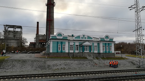
Photo
Where is located Muzey Shakhtorskoy Slavy Kol'chuginskogo Rudnika
Muzey Shakhtorskoy Slavy Kol'chuginskogo Rudnika — local attraction, which is located at Prospekt Kirova, 99/1, Leninsk-Kuznetskiy, Kemerovo Oblast, 652507 and belongs to the category — museum. Average visitor rating for this place — 4.8 (according to 10 ratings, information from open sources and relevant for 2022).
Exact location — Muzey Shakhtorskoy Slavy Kol'chuginskogo Rudnika, marked on the map with a red marker.
You can get directions to Muzey Shakhtorskoy Slavy Kol'chuginskogo Rudnika on the map from your location.
What else is interesting in Leninsk-Kuznetskiy? You can see all the sights if you go to the city page.
Coordinates
Muzey Shakhtorskoy Slavy Kol'chuginskogo Rudnika, Russian Federation coordinates in decimal format: latitude — 54.68520822754156, longitude — 86.1822096984143. When converted to degrees, minutes, seconds Muzey Shakhtorskoy Slavy Kol'chuginskogo Rudnika has the following coordinates: 54°41′6.75 north latitude and 86°10′55.95 east longitude.
Nearby cities
The largest cities that are located nearby:
- Prokopyevsk — 93 km
- Novokuznetsk — 117 km
- Mezhdurechensk — 164 km
- Novosibirsk — 208 km
- Barnaul — 214 km
- Tomsk — 216 km
- Seversk — 229 km
- Biysk — 243 km
- Achinsk — 319 km
- Abakan — 359 km
- Krasnoyarsk — 442 km
- Rubtsovsk — 487 km
- Oskemen
 (Kazakhstan) — 576 km
 - Kansk — 612 km
- Semey (Kazakhstan) — 627 km
- Kyzyl — 654 km
- Pavlodar (Kazakhstan) — 675 km
- Altay
 (China) — 767 km
 - Ekibastuz (Kazakhstan) — 811 km
Distance to the capital
Distance to the capital (Moscow) is about — 3020 km.