
 Bokamoso
Buysdorp
Xihosana
Ga-Sekororo
Ga-Rankuwa
Three Sisters
George
Haenertsburg
Polokwane
Bokamoso
Buysdorp
Xihosana
Ga-Sekororo
Ga-Rankuwa
Three Sisters
George
Haenertsburg
Polokwane
Family Fun Beach on the map, Vereeniging, South Africa
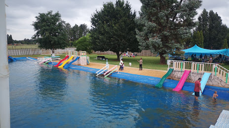
Photo
Where is located Family Fun Beach
Family Fun Beach — local attraction, which is located at 19 Van Der Walt Rd, Harmoniesrus, Vereeniging, 1929, South Africa and belongs to the category — water park. Average visitor rating for this place — 4.4 (according to 18 ratings, information from open sources and relevant for 2022).
Exact location — Family Fun Beach, marked on the map with a red marker.
You can get directions to Family Fun Beach on the map from your location.
What else is interesting in Vereeniging? You can see all the sights if you go to the city page.
Coordinates
Family Fun Beach, South Africa coordinates in decimal format: latitude — -26.60411795059803, longitude — 27.92372129756337. When converted to degrees, minutes, seconds Family Fun Beach has the following coordinates: -26°36′14.82 north latitude and 27°55′25.4 east longitude.
Nearby cities
The largest cities that are located nearby:
- Vanderbijlpark — 10 km
- Soweto — 48 km
- Westonaria — 49 km
- Johannesburg — 53 km
- Boksburg — 58 km
- Randfontein — 59 km
- Nigel — 61 km
- Roodepoort — 61 km
- Carletonville — 63 km
- Krugersdorp — 66 km
- Benoni — 66 km
- Springs — 69 km
- Midrand — 77 km
- Tembisa — 79 km
- Diepsloot — 82 km
- Potchefstroom — 83 km
- Centurion — 91 km
- Embalenhle — 114 km
- Brits — 118 km
Distance to the capital
Distance to the capital (Pretoria) is about — 99 km.