 Pointe-à-la-Croix
Sainte-Irène, Quebec
Marsoui
Hecla
Muskrat Dam
Wunnummin Lake
Sainte-Brigitte-de-Laval
Drayton
Mauricie
Pointe-à-la-Croix
Sainte-Irène, Quebec
Marsoui
Hecla
Muskrat Dam
Wunnummin Lake
Sainte-Brigitte-de-Laval
Drayton
Mauricie
Parlee Beach Provincial Park on the map, Moncton, Canada
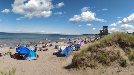
Photo
Where is located Parlee Beach Provincial Park
Parlee Beach Provincial Park — local attraction, which is located at 45 Parlee Beach Rd, Pointe-du-Chêne, NB E4P 8V5, Canada and belongs to the category — provincial park. Average visitor rating for this place — 4.4 (according to 1621 rating, information from open sources and relevant for 2022).
Exact location — Parlee Beach Provincial Park, marked on the map with a red marker.
You can get directions to Parlee Beach Provincial Park on the map from your location.
What else is interesting in Moncton? You can see all the sights if you go to the city page.
Coordinates
Parlee Beach Provincial Park, Canada coordinates in decimal format: latitude — 46.24025685991967, longitude — -64.5109241018915. When converted to degrees, minutes, seconds Parlee Beach Provincial Park has the following coordinates: 46°14′24.92 north latitude and -64°30′39.33 east longitude.
Nearby cities
The largest cities that are located nearby:
- Dartmouth — 184 km
- Halifax — 185 km
- Levis — 495 km
- Quebec — 496 km
- Saguenay — 529 km
- Sherbrooke — 557 km
- Trois-Rivières — 593 km
- Manchester
 (United States) — 639 km
 - Lowell (United States) — 655 km
- Boston (United States) — 658 km
- Cambridge (United States) — 660 km
- Longueuil — 679 km
- Montreal — 684 km
- Laval — 693 km
- Worcester (United States) — 714 km
- Providence (United States) — 722 km
- Amherst (United States) — 755 km
- Springfield (United States) — 778 km
- Hartford (United States) — 809 km
Distance to the capital
Distance to the capital (Ottawa) is about — 871 km.