
 Pedrola
Pallejà
Ayamonte
Iznájar
Alcublas
Aigües
La Llacuna
Trapiche
La Bañeza
Villalar de los Comuneros
Sorbas
La Huelga
Bédar
Rute
Cabezarrubias del Puerto
Las Ventas de Retamosa
Camarenilla
Nambroca
Villanueva de Gómez
Pedrola
Pallejà
Ayamonte
Iznájar
Alcublas
Aigües
La Llacuna
Trapiche
La Bañeza
Villalar de los Comuneros
Sorbas
La Huelga
Bédar
Rute
Cabezarrubias del Puerto
Las Ventas de Retamosa
Camarenilla
Nambroca
Villanueva de Gómez
Manzanares on the map, Spain
Where is located Manzanares
Exact location — Manzanares, Ciudad Real, Castilla-La Mancha, Spain, marked on the map with a red marker.
Coordinates
Manzanares, Spain coordinates in decimal format: latitude — 39.0042841, longitude — -3.3716443. When converted to degrees, minutes, seconds Manzanares has the following coordinates: 39°0′15.42 north latitude and -3°22′17.92 east longitude.
Population
Manzanares, Ciudad Real, Castilla-La Mancha, Spain, according to our data the population is — 18,306 residents, which is about 0% of the total population of the country (Spain).
Comparison of the population on the graph:
Exact time
Time zone for this location Manzanares — UTC +2 Europe/Madrid. Exact time — friday, 5 may 2024 year, 13 h. 11 minutes.
Sunrise and sunset
Manzanares, sunrise and sunset data for a date — friday 3.05.2024.
| Sunrise | Sunset | Day (duration) |
|---|---|---|
| 07:15 -1 minute | 21:05 +1 minute | 13 h. 48 minutes. +2 minutes |
You can control the scale of the map using the auxiliary tools to find out exactly where it is located Manzanares. When you change the scale of the map, the width of the ruler also changes (in kilometers and miles).
Nearby cities
The largest cities that are located nearby:
- Albacete — 130 km
- Jaén — 140 km
- Fuenlabrada — 147 km
- Getafe — 147 km
- Leganés — 151 km
- Móstoles — 152 km
- Alcorcón — 153 km
- Torrejón de Ardoz — 161 km
- Alcala de Henares — 163 km
- Alcobendas — 171 km
- Córdoba — 174 km
- Granada — 203 km
- Murcia — 225 km
- Almería — 253 km
- Cartagena — 258 km
- Valencia — 261 km
- Málaga — 269 km
- Salamanca — 290 km
- Dos Hermanas — 294 km
Distance to neighboring capitals:
- Lisbon
 (Portugal) — 500 km
 - Andorra la Vella
 (Andorra) — 567 km
 - Rabat
 (Morocco) — 640 km
 - Paris
 (France) — 1187 km
 - Paris (France) — 1187 km
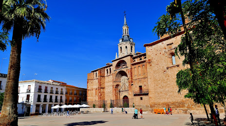
Attractions


Distance to the capital
Distance to the capital (Madrid) is about — 160 km.