
 Belém
Maranguape
Paranaguá
Paranaguá
Monte Alegre
Alvorada de Minas
Bragança
Laguna
Ibiporã
Belém
Maranguape
Paranaguá
Paranaguá
Monte Alegre
Alvorada de Minas
Bragança
Laguna
Ibiporã
Museum Júlio de Castilhos on the map, Porto Alegre, Brazil
Photo
Where is located Museum Júlio de Castilhos
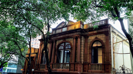
Museum Júlio de Castilhos — local attraction, which is located at R. Duque de Caxias, 1205 - Centro Histórico, Porto Alegre - RS, 90010-281, Brazil and belongs to the category — museum. Average visitor rating for this place — 4.4 (according to 523 ratings, information from open sources and relevant for 2022).
Exact location — Museum Júlio de Castilhos, marked on the map with a red marker.
You can get directions to Museum Júlio de Castilhos on the map from your location.
What else is interesting in Porto Alegre? You can see all the sights if you go to the city page.
Coordinates
Museum Júlio de Castilhos, Brazil coordinates in decimal format: latitude — -30.038709969395054, longitude — -51.222521348556434. When converted to degrees, minutes, seconds Museum Júlio de Castilhos has the following coordinates: -30°2′19.36 north latitude and -51°13′21.08 east longitude.
Nearby cities
The largest cities that are located nearby:
- Guaíba — 13 km
- Canoas — 14 km
- Cachoeirinha — 15 km
- Viamão — 20 km
- Gravataí — 24 km
- São Leopoldo — 32 km
- Novo Hamburgo — 39 km
- Caxias do Sul — 96 km
- Santa Cruz do Sul — 122 km
- Pelotas — 218 km
- Passo Fundo — 228 km
- Criciúma — 234 km
- Rio Grande — 236 km
- Santa Maria — 252 km
- Lages — 260 km
- Chapecó — 352 km
- Palhoça — 363 km
- São José — 368 km
- Florianópolis — 376 km