
 Belém
Maranguape
Paranaguá
Paranaguá
Monte Alegre
Alvorada de Minas
Bragança
Laguna
Ibiporã
Belém
Maranguape
Paranaguá
Paranaguá
Monte Alegre
Alvorada de Minas
Bragança
Laguna
Ibiporã
Praia Da Chaleirinha on the map, Serra, Brazil
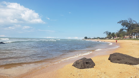
Photo
Where is located Praia Da Chaleirinha
Praia Da Chaleirinha — local attraction, which is located at Av. Atapoã, 02 - Manguinhos, Serra - ES, 29173-000, Brazil and belongs to the category — public beach. Average visitor rating for this place — 4.6 (according to 1021 rating, information from open sources and relevant for 2022).
Exact location — Praia Da Chaleirinha, marked on the map with a red marker.
You can get directions to Praia Da Chaleirinha on the map from your location.
What else is interesting in Serra? You can see all the sights if you go to the city page.
Coordinates
Praia Da Chaleirinha, Brazil coordinates in decimal format: latitude — -20.187595674651828, longitude — -40.190641292847076. When converted to degrees, minutes, seconds Praia Da Chaleirinha has the following coordinates: -20°11′15.34 north latitude and -40°11′26.31 east longitude.
Nearby cities
The largest cities that are located nearby:
- Cariacica — 20 km
- Vila Velha — 25 km
- Guarapari — 64 km
- Colatina — 77 km
- Linhares — 84 km
- Cachoeiro de Itapemirim — 116 km
- Valadares Governor — 222 km
- Coronel Fabriciano — 251 km
- Teófilo Otoni — 280 km
- Macaé — 292 km
- Cabo Frio — 352 km
- Juiz de Fora — 361 km
- Araruama — 367 km
- Sabará — 367 km
- Teresópolis — 372 km
- Barbacena — 377 km
- Belo Horizonte — 378 km
- Santa Luzia — 380 km
- Ibirité — 390 km