
 Puerto de la Duquesa
La Serna de Iguña
Pumalverde
Puentenansa
La Iglesia
Casar de Periedo
Fuengirola
Renedo de Piélagos
Villabanez
Puerto de la Duquesa
La Serna de Iguña
Pumalverde
Puentenansa
La Iglesia
Casar de Periedo
Fuengirola
Renedo de Piélagos
Villabanez
Convent de Santa Clara on the map, Palma, Spain
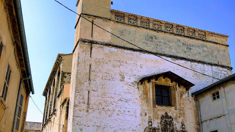
Photo
Where is located Convent de Santa Clara
Convent de Santa Clara — local attraction, which is located at Carrer de Can Fonollar, 2, 07001 Palma, Illes Balears, Spain and belongs to the category — convent. Average visitor rating for this place — 4.6 (according to 278 ratings, information from open sources and relevant for 2022).
Exact location — Convent de Santa Clara, marked on the map with a red marker.
You can get directions to Convent de Santa Clara on the map from your location.
What else is interesting in Palma? You can see all the sights if you go to the city page.
Coordinates
Convent de Santa Clara, Spain coordinates in decimal format: latitude — 39.56676708476944, longitude — 2.6515391076044597. When converted to degrees, minutes, seconds Convent de Santa Clara has the following coordinates: 39°34′0.36 north latitude and 2°39′5.54 east longitude.
Nearby cities
The largest cities that are located nearby:
- L'Hospitalet de Llobregat — 204 km
- Tarragona — 207 km
- Badalona — 210 km
- Santa Coloma de Gramenet — 210 km
- Mataró — 218 km
- Sabadell — 223 km
- Terrassa — 227 km
- Valencia — 259 km
- Lleida — 282 km
- Sidi M'Hamed
 (Algeria) — 313 km
 - Perpignan
 (France) — 345 km
 - Médéa (Algeria) — 365 km
- Zaragoza — 372 km
- Murcia — 373 km
- Bejaia (Algeria) — 378 km
- Cartagena — 385 km
- Albacete — 393 km
- Chlef (Algeria) — 394 km
- Bou Arreridj Bordj (Algeria) — 430 km
Distance to the capital
Distance to the capital (Madrid) is about — 550 km.